IMAGES TAKEN NEAR TO
Summerfield Avenue, KINGSWINFORD, DY6 9AR
Introduction
This page details the photographs taken nearby to Summerfield Avenue, DY6 9AR by members of the Geograph project.
The Geograph project started in 2005 with the aim of publishing, organising and preserving representative images for every square kilometre of Great Britain, Ireland and the Isle of Man.

There are currently over 7.5m images from over14,400 individuals and you can help contribute to the project by visiting https://www.geograph.org.uk
Image Map
Images are licensed for reuse under creativecommons.org/licenses/by-sa/2.0
Notes
- Clicking on the map will re-center to the selected point.
- The higher the marker number, the further away the image location is from the centre of the postcode.
Image Listing (16 Images Found)
Images are licensed for reuse under creativecommons.org/licenses/by-sa/2.0
Image
Details
Distance
1
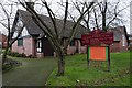
St Andrew's Church Wall Heath
St Andrew's United Reformed church Wall Heath.
Image: © Nigel Cliff
Taken: 30 Dec 2011
0.19 miles
2
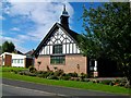
Saint Andrew's United Reformed Church
Image: © Stephen Rogerson
Taken: 9 Aug 2013
0.20 miles
3
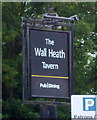
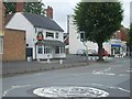
Sign for the Wall Heath Tavern, Wall Heath, Kingswinford
See Image] for context.
Image: © JThomas
Taken: 8 Jun 2019
0.22 miles
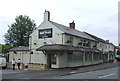
4
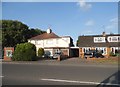
The Horse & Jockey
A Banks Pub at Wall Heath.
Image: © Gordon Griffiths
Taken: 14 Jul 2008
0.22 miles
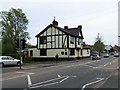
5
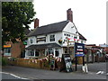
The Wall Heath Tavern, Wall Heath, Kingswinford
Formerly the Top House.
On High Street.
Image: © JThomas
Taken: 8 Jun 2019
0.22 miles
7
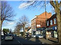
Wall Heath Shops
The view of the shops on the High Street (A449) in Wall Haeth.
Image: © Gordon Griffiths
Taken: 15 Feb 2018
0.23 miles
9
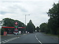
Texaco filling station on Kidderminster Road
Image: © Colin Pyle
Taken: 7 Aug 2015
0.24 miles