IMAGES TAKEN NEAR TO
The Rise, KINGSWINFORD, DY6 8LB
Introduction
This page details the photographs taken nearby to The Rise, DY6 8LB by members of the Geograph project.
The Geograph project started in 2005 with the aim of publishing, organising and preserving representative images for every square kilometre of Great Britain, Ireland and the Isle of Man.

There are currently over 7.5m images from over14,400 individuals and you can help contribute to the project by visiting https://www.geograph.org.uk
Image Map
Images are licensed for reuse under creativecommons.org/licenses/by-sa/2.0
Notes
- Clicking on the map will re-center to the selected point.
- The higher the marker number, the further away the image location is from the centre of the postcode.
Image Listing (15 Images Found)
Images are licensed for reuse under creativecommons.org/licenses/by-sa/2.0
Image
Details
Distance
1
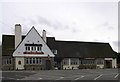
The Summerhouse Pub, The Portway, Kingswinford
A spacious and once popular public house, it now only opens in the evenings. Many pubs such as this are closing down in urban and rural parts of the West Midlands. How long will it be before this sizeable piece of land is developed with yet another different style of housing? (See my comments on other photographs taken in this road).
Image: © Roger Kidd
Taken: 12 Mar 2007
0.10 miles
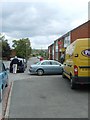
2

The Summerhouse (Chamberlains) (1), The Portway, Kingswinford, Dudley
A large estate public house in this residential area. It was open when photographed on a Saturday afternoon, so its opening hours seem to have been extended since it was photographed for this site some years ago.
Image
Image: © P L Chadwick
Taken: 9 Nov 2013
0.12 miles
4
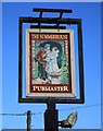
The Summerhouse (Chamberlains) (2) - sign, The Portway, Kingswinford, Dudley
The sign is on a post at the front of the car park. The Summerhouse is branded Pubmaster, part of Punch Taverns plc.
Image
Image: © P L Chadwick
Taken: 9 Nov 2013
0.13 miles
5
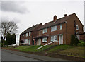
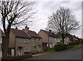
More Housing - The Portway, Kingswinford
Another style of housing to add to the many in this road. There are examples of residences from the late 1890s/early 1900s (at the western end), 1920s, 1940s, 1960s-70s, and the late 20th century - real random and unco-ordinated spread of dwellings.
Image: © Roger Kidd
Taken: 12 Mar 2007
0.14 miles
6
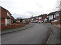
Housing - The Portway, Kingswinford
As the road ascends the hill from the High Street, the hotch-potch of development continues with its random mixture of houses dating from all periods of the last 100 years. These are from the 1960s (?).
Image: © Roger Kidd
Taken: 12 Mar 2007
0.17 miles
7
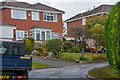
Fairview Crescent
The view along the crescent in Kingswinford, Dudley.
Image: © Gordon Griffiths
Taken: 8 Dec 2020
0.18 miles
8
Kingswinford : Southbank View
Looking along Southbank View off Bromley Lane.
Image: © Lewis Clarke
Taken: 28 Sep 2019
0.20 miles
9

Kingswinford : Standhills Road
Looking along Standhills Road off Bromley Lane.
Image: © Lewis Clarke
Taken: 28 Sep 2019
0.20 miles
10
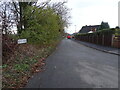
Ketley Road View
The view along Ketley Road in Kingswinford, Dudley.
Image: © Gordon Griffiths
Taken: 8 Dec 2020
0.20 miles