IMAGES TAKEN NEAR TO
Clover Lane, KINGSWINFORD, DY6 0DT
Introduction
This page details the photographs taken nearby to Clover Lane, DY6 0DT by members of the Geograph project.
The Geograph project started in 2005 with the aim of publishing, organising and preserving representative images for every square kilometre of Great Britain, Ireland and the Isle of Man.

There are currently over 7.5m images from over14,400 individuals and you can help contribute to the project by visiting https://www.geograph.org.uk
Image Map
Images are licensed for reuse under creativecommons.org/licenses/by-sa/2.0
Notes
- Clicking on the map will re-center to the selected point.
- The higher the marker number, the further away the image location is from the centre of the postcode.
Image Listing (19 Images Found)
Images are licensed for reuse under creativecommons.org/licenses/by-sa/2.0
Image
Details
Distance
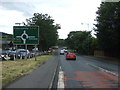
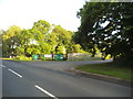
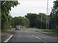
2
Wall Heath - Kidderminster Road (A449)
Note the "route confirmatory" sign indicating that this is considered a "primary route" and hence distances are given to the next major locations.
Image: © J Whatley
Taken: 6 Sep 2010
0.06 miles
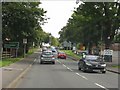
3
Wall Heath - Kidderminster Road at Highbridge Road
Image: © J Whatley
Taken: 6 Sep 2010
0.08 miles
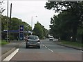
4
Kidderminster Road, Kingswinford
The A449 approaching a roundabout.
Image: © JThomas
Taken: 8 Jun 2019
0.09 miles
6
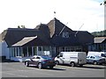
The Kingfisher Country Club
More Info http://www.thekingfisherclub.co.uk/
Image: © Stephen Rogerson
Taken: 9 Aug 2013
0.11 miles
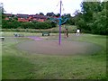
8
Golf Range
The view on Swindon Road, Wall Heath, Dudley.
Image: © Gordon Griffiths
Taken: 2 Jun 2016
0.14 miles
9
Wall Heath - Swindon Road roundabout from the northbound A449
Image: © J Whatley
Taken: 6 Sep 2010
0.16 miles
