IMAGES TAKEN NEAR TO
High Street, BRIERLEY HILL, DY5 4RS
Introduction
This page details the photographs taken nearby to High Street, DY5 4RS by members of the Geograph project.
The Geograph project started in 2005 with the aim of publishing, organising and preserving representative images for every square kilometre of Great Britain, Ireland and the Isle of Man.

There are currently over 7.5m images from over14,400 individuals and you can help contribute to the project by visiting https://www.geograph.org.uk
Image Map (Loading...)


Getting Data...Please wait
Leaflet Map data © OpenStreetMap
Images are licensed for reuse under creativecommons.org/licenses/by-sa/2.0
Notes
- Clicking on the map will re-center to the selected point.
- The higher the marker number, the further away the image location is from the centre of the postcode.
Image Listing (23 Images Found)
Images are licensed for reuse under creativecommons.org/licenses/by-sa/2.0
Image
Details
Distance
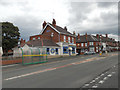
1
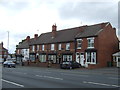
Goodies Chips
The former Four Furnaces Pub Image is now a Fish and Chip shop on High Street, Pensnett.
Image: © Gordon Griffiths
Taken: 8 Sep 2010
0.08 miles
3
Bus stop outside Goodies Chips, High St, Tansey Green
Image: © Row17
Taken: 18 Sep 2010
0.09 miles
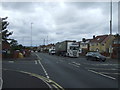
4
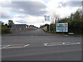
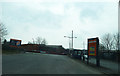
Dreadnought Road
The view down the Pensnett road in Dudley.
Image: © Gordon Griffiths
Taken: 25 Jul 2015
0.11 miles
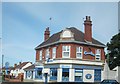
5
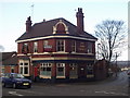
The Four Furnaces, Pensnett.
Public house located at the junction of High Street and Tansey Green Road, Pensnett.
Image: © Brian Clift
Taken: 1 Mar 2007
0.12 miles
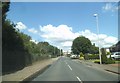
7
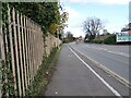
Gibbons Lane
The view from the A4101 in Kingswinford, Dudley.
Image: © Gordon Griffiths
Taken: 3 Nov 2020
0.15 miles
8
Dudley Road Scene
The view along the A4101 in Kingswinford, Dudley.
Image: © Gordon Griffiths
Taken: 3 Nov 2020
0.15 miles
10
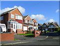
Corbyns Close
A quiet suburb between Dudley and Kingswinford.
Image: © Jonathan Billinger
Taken: 21 Oct 2008
0.17 miles