IMAGES TAKEN NEAR TO
Chelmar Drive, BRIERLEY HILL, DY5 4QE
Introduction
This page details the photographs taken nearby to Chelmar Drive, DY5 4QE by members of the Geograph project.
The Geograph project started in 2005 with the aim of publishing, organising and preserving representative images for every square kilometre of Great Britain, Ireland and the Isle of Man.

There are currently over 7.5m images from over14,400 individuals and you can help contribute to the project by visiting https://www.geograph.org.uk
Image Map
Images are licensed for reuse under creativecommons.org/licenses/by-sa/2.0
Notes
- Clicking on the map will re-center to the selected point.
- The higher the marker number, the further away the image location is from the centre of the postcode.
Image Listing (9 Images Found)
Images are licensed for reuse under creativecommons.org/licenses/by-sa/2.0
Image
Details
Distance
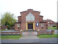
1
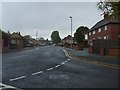
Tile House Lane View
A Street view in Pensnett, Dudley.
Image: © Gordon Griffiths
Taken: 29 Oct 2011
0.10 miles
2

Tiled House Lane Shops
A Street in Pensnett, Dudley.
Image: © Gordon Griffiths
Taken: 25 Apr 2009
0.12 miles
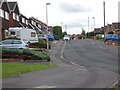
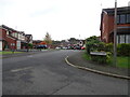
3
Booth Close
The view in the housing estate in Bromley, Dudley.
Image: © Gordon Griffiths
Taken: 13 Oct 2021
0.18 miles
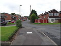
4

Dunlin Close
The view from Ploverdale Crescent in the housing estate in Kingswinford, Dudley.
Image: © Gordon Griffiths
Taken: 21 Feb 2023
0.20 miles
5

Sanderling Rise View
The view up Ploverdale Crescent in the housing estate in Kingswinford, Dudley.
Image: © Gordon Griffiths
Taken: 21 Feb 2023
0.21 miles
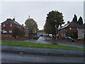
6
Blenheim Road
The view in the housing estate in Bromley, Dudley.
Image: © Gordon Griffiths
Taken: 13 Oct 2021
0.21 miles
7
Tile House Lane Scene
A cul-de-sac view in Pensnett, Dudley.
Image: © Gordon Griffiths
Taken: 29 Oct 2011
0.23 miles
9
Meadowsweet Way View
The view along Ploverdale Crescent in the housing estate in Bromley, Dudley.
Image: © Gordon Griffiths
Taken: 13 Oct 2021
0.25 miles