IMAGES TAKEN NEAR TO
Campbell Street, BRIERLEY HILL, DY5 3YB
Introduction
This page details the photographs taken nearby to Campbell Street, DY5 3YB by members of the Geograph project.
The Geograph project started in 2005 with the aim of publishing, organising and preserving representative images for every square kilometre of Great Britain, Ireland and the Isle of Man.

There are currently over 7.5m images from over14,400 individuals and you can help contribute to the project by visiting https://www.geograph.org.uk
Image Map (Loading...)


Getting Data...Please wait
Leaflet Map data © OpenStreetMap
Images are licensed for reuse under creativecommons.org/licenses/by-sa/2.0
Notes
- Clicking on the map will re-center to the selected point.
- The higher the marker number, the further away the image location is from the centre of the postcode.
Image Listing (91 Images Found)
Images are licensed for reuse under creativecommons.org/licenses/by-sa/2.0
Image
Details
Distance
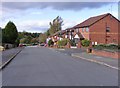
1
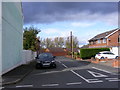
Campbell Street Scene
The view in Brockmoor, Brierley Hill, Dudley.
Image: © Gordon Griffiths
Taken: 12 Oct 2017
0.02 miles
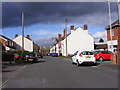
2
Raglan Street
The view in Brierley Hill, Dudley.
Image: © Gordon Griffiths
Taken: 12 Oct 2017
0.03 miles
3
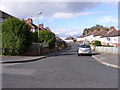
Wilson Road
The view in Brierley Hill, Dudley.
Image: © Gordon Griffiths
Taken: 12 Oct 2017
0.04 miles
4
Fox Foot Drive
The view in Brierley Hill.
Image: © Gordon Griffiths
Taken: 12 Oct 2017
0.06 miles
5
Cressett Lane
The view in Brierley Hill.
Image: © Gordon Griffiths
Taken: 12 Oct 2017
0.06 miles
6

Path Junction View
The path junction for Buckpool nature reserve and the Dell Stadium off Pensnett Road, Dudley.
Image: © Gordon Griffiths
Taken: 7 Jul 2013
0.07 miles
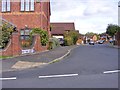
7
Campbell Street View
The view in Brierley Hill, Dudley.
Image: © Gordon Griffiths
Taken: 12 Oct 2017
0.07 miles
8
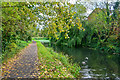
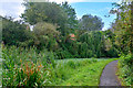
Brierley Hill : Fens Branch
Fens Branch canal in Dudley.
Image: © Lewis Clarke
Taken: 28 Sep 2019
0.07 miles
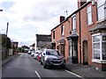
9
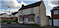
Foresters Arms, Cressett Lane
This pub has been closed for years (see Image, but its name and that of its brewery (Courage) remain legible on the frontage. It is perhaps the oldest extant building in the vicinity - the brickwork looks old and it appears on the 1880s Ordnance Survey large scale maps under the name of Rock Tavern. It will probably be demolished as the site on which it stands has been subject to at least one planning application.
Image: © Paul Collins
Taken: 29 Jul 2023
0.07 miles
10
Brierley Hill : Fens Branch
A canal heading through Brierley Hill.
Image: © Lewis Clarke
Taken: 28 Sep 2019
0.07 miles