IMAGES TAKEN NEAR TO
Knott Court, BRIERLEY HILL, DY5 2UH
Introduction
This page details the photographs taken nearby to Knott Court, DY5 2UH by members of the Geograph project.
The Geograph project started in 2005 with the aim of publishing, organising and preserving representative images for every square kilometre of Great Britain, Ireland and the Isle of Man.

There are currently over 7.5m images from over14,400 individuals and you can help contribute to the project by visiting https://www.geograph.org.uk
Image Map
Images are licensed for reuse under creativecommons.org/licenses/by-sa/2.0
Notes
- Clicking on the map will re-center to the selected point.
- The higher the marker number, the further away the image location is from the centre of the postcode.
Image Listing (343 Images Found)
Images are licensed for reuse under creativecommons.org/licenses/by-sa/2.0
Image
Details
Distance
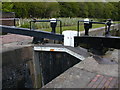
1
Delph Locks
Detail of the brickwork of one of the locks.
Image: © Brian Clift
Taken: 24 Sep 2009
0.03 miles
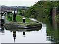
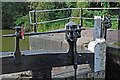
2
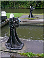
Ground paddle gear at Delph Locks No 6, Brierley Hill
By use of a right-angled metal tool called a windlass, the gear which is attached to an underground paddle by a steel rod below the ratchet, can be raised, allowing water through a culvert into the lock. This flow ceases when the level is the same in the lock chamber as it is in the canal to the right of the gate, which can then be (quite) easily swung open by pushing the balance beam (off to the right). The paddle can then be lowered carefully (NOT DROPPED!)
Image]
Image: © Roger Kidd
Taken: 26 Aug 2010
0.03 miles
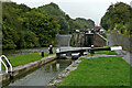
3
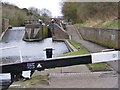
Lock No5 View
The view up the Delph Nine locks on the Dudley No1 Canal in Brierley Hill, Dudley.
Image: © Gordon Griffiths
Taken: 21 Feb 2016
0.03 miles
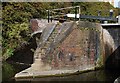
4
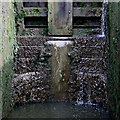
Overflow channel by Delph Locks No 5 near Brierley Hill
There are short wide pounds between each lock and sideponds which help in the water management. On the right as you look south-west, broad weirs by locks 2 to 7 allow surplus water to cascade down into the next pound in the manner of a waterfall.
Image]
On the Dudley No 1 Canal, eight locks in the Delph flight provide a fall (or rise) of 85 feet (just under 26 metres) on the Dudley No 1 Canal near Brierley Hill. Originally there were nine locks, opened in 1779, but in the mid 1850s the course was adjusted and the flight rebuilt as eight locks, just the top and bottom ones now being in their original positions. The new flight opened in 1858.
Image: © Roger Kidd
Taken: 27 Aug 2010
0.03 miles
5
Falling off the world - Delph "Nine Locks"
There are only 8 of them, due to rebuilding!
Image: © Peter Whatley
Taken: 6 Jun 1988
0.03 miles
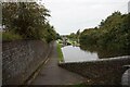
6
Delph Locks No 6 near Brierley Hill, Dudley
Looking north-east towards Lock No 5 and Merry Hill.
The image shows the tailgates and overflow at Delph Locks No 4. There are short pounds between each lock and sideponds which help in the water management. The locks, stables, basin bridge and lock cottage at the bottom of the flight are all Grade II listed.
Image]
On the Dudley No 1 Canal, eight locks in the Delph flight provide a fall (or rise) of 85 feet (just under 26 metres) on the Dudley No 1 Canal near Brierley Hill. Originally there were nine locks, opened in 1779, but in the mid 1850s the course was adjusted and the flight rebuilt as eight locks, just the top and bottom ones now being in their original sites. The new flight opened in 1858.
Image: © Roger Kidd
Taken: 26 Aug 2010
0.03 miles
8
Delph Locks
A detail of one of the locks showing the date of construction.
Image: © Brian Clift
Taken: 24 Sep 2009
0.03 miles
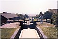
9
Lock cill in the Delph flight near Brierley Hill
This is at Delph Locks No 5.
When draining the lock to descend, boat crews MUST keep the rear of the boat forward of the stone cill. Failure to do this can result in the stern catching it, the bow dipping, and possible sinking of the boat. White markers are painted on the side of all locks to assist.
Image]
Image: © Roger Kidd
Taken: 27 Aug 2010
0.03 miles