IMAGES TAKEN NEAR TO
Cowslip Walk, BRIERLEY HILL, DY5 2QN
Introduction
This page details the photographs taken nearby to Cowslip Walk, DY5 2QN by members of the Geograph project.
The Geograph project started in 2005 with the aim of publishing, organising and preserving representative images for every square kilometre of Great Britain, Ireland and the Isle of Man.

There are currently over 7.5m images from over14,400 individuals and you can help contribute to the project by visiting https://www.geograph.org.uk
Image Map
Images are licensed for reuse under creativecommons.org/licenses/by-sa/2.0
Notes
- Clicking on the map will re-center to the selected point.
- The higher the marker number, the further away the image location is from the centre of the postcode.
Image Listing (5 Images Found)
Images are licensed for reuse under creativecommons.org/licenses/by-sa/2.0
Image
Details
Distance
1
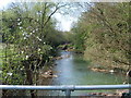
River Stour
A footbridge over the Stour off Bagley's Road.
Image: © Gordon Griffiths
Taken: 15 Apr 2007
0.13 miles
2
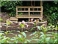
River Stour at Stambermill
You can just see the river through the undergrowth. The other side there is a view point at the bottom of a house.
Image: © Stephen Rogerson
Taken: 19 Jul 2012
0.13 miles
3
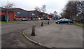
Stambermill Industrial Estate
An estate of small industrial units on Timmis Road, Lye
Image: © David Lally
Taken: 18 Dec 2007
0.19 miles
4
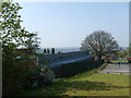
Peter's Hill View
The view towards Stourbridge Town over Peters Hill School.
Image: © Gordon Griffiths
Taken: 15 Apr 2007
0.22 miles