IMAGES TAKEN NEAR TO
Grosvenor Way, BRIERLEY HILL, DY5 2LG
Introduction
This page details the photographs taken nearby to Grosvenor Way, DY5 2LG by members of the Geograph project.
The Geograph project started in 2005 with the aim of publishing, organising and preserving representative images for every square kilometre of Great Britain, Ireland and the Isle of Man.

There are currently over 7.5m images from over14,400 individuals and you can help contribute to the project by visiting https://www.geograph.org.uk
Image Map
Images are licensed for reuse under creativecommons.org/licenses/by-sa/2.0
Notes
- Clicking on the map will re-center to the selected point.
- The higher the marker number, the further away the image location is from the centre of the postcode.
Image Listing (35 Images Found)
Images are licensed for reuse under creativecommons.org/licenses/by-sa/2.0
Image
Details
Distance
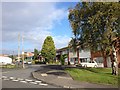
2
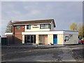
Grosvenor Way, Dunn's Bank
Off Caledonia.
Image: © Richard Vince
Taken: 6 Jul 2024
0.06 miles
3
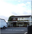
Caledonia View
The view in Lye, Dudley.
Image: © Gordon Griffiths
Taken: 11 Jun 2017
0.06 miles
5
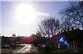
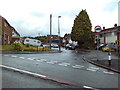
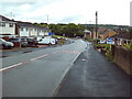
Mousehall Farm Road Scene
The view down the road in Quarry Bank Dudley, into the low December evening sun.
Image: © Gordon Griffiths
Taken: 4 Dec 2016
0.08 miles
6
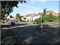
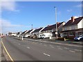
Lye - Caledonia
Not Caledonia Street or Road, just Caledonia. Most odd!
Image: © Peter Whatley
Taken: 9 Oct 2008
0.08 miles
7
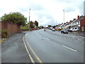
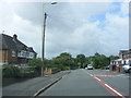
Thorns Road, Dunn's Bank
Climbing towards Merry Hill.
Image: © Richard Vince
Taken: 6 Jul 2024
0.08 miles
9
East end of Caledonia, Dunn's Bank
Descending to meet Thorns Road.
Image: © Richard Vince
Taken: 6 Jul 2024
0.09 miles