IMAGES TAKEN NEAR TO
Dudley Road, BRIERLEY HILL, DY5 1HG
Introduction
This page details the photographs taken nearby to Dudley Road, DY5 1HG by members of the Geograph project.
The Geograph project started in 2005 with the aim of publishing, organising and preserving representative images for every square kilometre of Great Britain, Ireland and the Isle of Man.

There are currently over 7.5m images from over14,400 individuals and you can help contribute to the project by visiting https://www.geograph.org.uk
Image Map
Images are licensed for reuse under creativecommons.org/licenses/by-sa/2.0
Notes
- Clicking on the map will re-center to the selected point.
- The higher the marker number, the further away the image location is from the centre of the postcode.
Image Listing (175 Images Found)
Images are licensed for reuse under creativecommons.org/licenses/by-sa/2.0
Image
Details
Distance
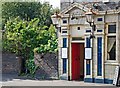
1
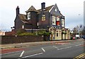
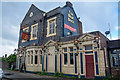
The Blue Brick (1), 153 Dudley Road, Brierley Hill, Dudley
A large Marston's public house not far from Merry Hill Shopping Centre. The pub does meals but currently most of its trade is from drinks. The building was a public house from the time of its construction in 1856, and around 1914 was acquired by the former Kidderminster Brewery Co. Ltd. In 1925 it passed to Wolverhampton & Dudley Breweries Ltd. The address was for a long time 2 Round Oak, the pub being adjacent to the former Round Oak Railway Station.
Image
Image: © P L Chadwick
Taken: 22 Nov 2015
0.01 miles
2
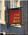
The Blue Brick (2) - sign, 153 Dudley Road, Brierley Hill, Dudley
This Marston's public house has been named after the blue bricks used in its construction. When this pub opened in 1856 it was known as the Commercial Inn. In 1892 it became the Blue Brick Commercial Hotel. Later it was for a while known as the Blue Brick Tap House (then being a Banks's house).
Image
Image: © P L Chadwick
Taken: 22 Nov 2015
0.01 miles
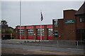
3
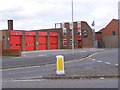
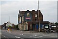
Brierley Hill Fire Station
The station on Dudley Road.
Image: © Gordon Griffiths
Taken: 25 Apr 2009
0.02 miles
4
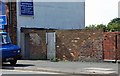
Dudley Road, Round Oak
This section of brick wall and gate was the location of the entrance to the southbound platform of Round Oak railway station.
Image: © Brian Clift
Taken: 9 Sep 2009
0.02 miles
6
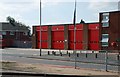
Dudley Road, Round Oak
Round Oak Fire Station located on Dudley Road near the junction with John Street.
Image: © Brian Clift
Taken: 9 Sep 2009
0.03 miles
7
Dudley Road, Round Oak
This shows the entrance to the Blue Brick public house and on the left the gate that led to the northbound platform of Round Oak railway station.
Image: © Brian Clift
Taken: 9 Sep 2009
0.03 miles
8
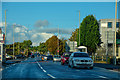
Brierley Hill : Dudley Road A461
Looking along Dudley Road.
Image: © Lewis Clarke
Taken: 27 Sep 2019
0.04 miles
9
Brierley Hill : The Blue Brick
This Marston's public house has been named after the blue bricks used in its construction.
Image: © Lewis Clarke
Taken: 28 Sep 2019
0.04 miles
10
The Blue Brick public house
On Dudley Road, Brierley Hill.
Image: © Ian S
Taken: 4 Sep 2021
0.04 miles