IMAGES TAKEN NEAR TO
Charter Road, TIPTON, DY4 0HU
Introduction
This page details the photographs taken nearby to Charter Road, DY4 0HU by members of the Geograph project.
The Geograph project started in 2005 with the aim of publishing, organising and preserving representative images for every square kilometre of Great Britain, Ireland and the Isle of Man.

There are currently over 7.5m images from over14,400 individuals and you can help contribute to the project by visiting https://www.geograph.org.uk
Image Map
Images are licensed for reuse under creativecommons.org/licenses/by-sa/2.0
Notes
- Clicking on the map will re-center to the selected point.
- The higher the marker number, the further away the image location is from the centre of the postcode.
Image Listing (9 Images Found)
Images are licensed for reuse under creativecommons.org/licenses/by-sa/2.0
Image
Details
Distance
2
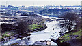
Gospel Oak branch of Walsall Canal, 1979
A truly desolate scene showing the long-abandoned Gospel Oak canal branch from its terminus at Gospel Oak Road. Captain Ahab's website has it that the branch was abandoned in 1954 but still had use as a feeder for the canal system ahead - http://captainahabswaterytales.blogspot.com/2010/12/gospel-oak-branch-bcn-upper-reaches.html.
The scene is entirely different now; the post-industrial waste ground has been developed for housing and the canal route adapted to become a linear park and footpath. The northern end of the branch still has a stretch of water at its junction with the Walsall Canal, as Richard Vince's image shows - https://www.geograph.org.uk/photo/6392737.
Image: © Trevor Littlewood
Taken: 14 Apr 1979
0.15 miles
3
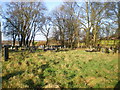
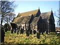
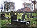
Graveyard of St Mark's Church, Ocker Hill
Image: © Richard Law
Taken: 30 Nov 2009
0.17 miles

8
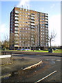
Flats at Ocker Hill
One of a pair of matched blocks of flats; I couldn't photograph both, as it would have been too much 'into the sun' to work properly.
Image: © Richard Law
Taken: 30 Nov 2009
0.23 miles
9
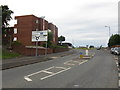
Ocker Hill Island
The junction of Toll End Road to the A4037.
Image: © Gordon Griffiths
Taken: 13 Apr 2009
0.24 miles