IMAGES TAKEN NEAR TO
Feiashill Road, DUDLEY, DY3 4PT
Introduction
This page details the photographs taken nearby to Feiashill Road, DY3 4PT by members of the Geograph project.
The Geograph project started in 2005 with the aim of publishing, organising and preserving representative images for every square kilometre of Great Britain, Ireland and the Isle of Man.

There are currently over 7.5m images from over14,400 individuals and you can help contribute to the project by visiting https://www.geograph.org.uk
Image Map
Images are licensed for reuse under creativecommons.org/licenses/by-sa/2.0
Notes
- Clicking on the map will re-center to the selected point.
- The higher the marker number, the further away the image location is from the centre of the postcode.
Image Listing (11 Images Found)
Images are licensed for reuse under creativecommons.org/licenses/by-sa/2.0
Image
Details
Distance
1
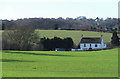
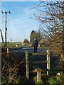
Farm Land west of Wombourne, Staffordshire
Image: © Roger D Kidd
Taken: 1 Feb 2008
0.07 miles
3
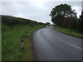
Bridgnorth Road
Looking uphill on the B4176, Smestow Gate.
Image: © JThomas
Taken: 8 Jun 2019
0.11 miles
5
Road Crossing
The Footpath to Trysull crosses the Bridgnorth Road.
Image: © Gordon Griffiths
Taken: 11 Feb 2008
0.16 miles
6
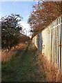
Bridleway to Trysull
Along the bridleway between Smestow and Trysull
Image: © Richard Law
Taken: 27 Sep 2011
0.18 miles
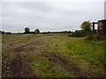
7
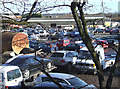
Car Auction in Progress, Smestow Bridge, Staffordshire
On the Smestow Bridge Industrial Estate.
Image: © Roger D Kidd
Taken: 30 Jan 2008
0.20 miles

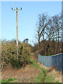
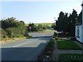
10
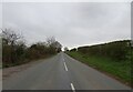
Feiashill Road Scene
The view near Smestow, Staffordshire.
Image: © Gordon Griffiths
Taken: 1 Apr 2021
0.21 miles