IMAGES TAKEN NEAR TO
High Street, DUDLEY, DY3 4NR
Introduction
This page details the photographs taken nearby to High Street, DY3 4NR by members of the Geograph project.
The Geograph project started in 2005 with the aim of publishing, organising and preserving representative images for every square kilometre of Great Britain, Ireland and the Isle of Man.

There are currently over 7.5m images from over14,400 individuals and you can help contribute to the project by visiting https://www.geograph.org.uk
Image Map (Loading...)


Getting Data...Please wait
Leaflet Map data © OpenStreetMap
Images are licensed for reuse under creativecommons.org/licenses/by-sa/2.0
Notes
- Clicking on the map will re-center to the selected point.
- The higher the marker number, the further away the image location is from the centre of the postcode.
Image Listing (178 Images Found)
Images are licensed for reuse under creativecommons.org/licenses/by-sa/2.0
Image
Details
Distance
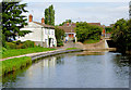
1
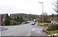
High Street View
The view from Swindon Bridge over the Staffordshire and Worcestershire Canal.
Image: © Gordon Griffiths
Taken: 12 Oct 2012
0.01 miles
2
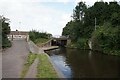
Swindon Bridge, Staffordshire & Worcestershire Canal
Image: © Ian S
Taken: 4 Sep 2021
0.02 miles
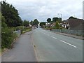
3
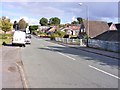
High Street looking southwest, Swindon, Staffs
This part of the High Street is mainly residential.
Image: © P L Chadwick
Taken: 22 Jan 2012
0.02 miles
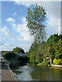
4
Canal near Swindon in Staffordshire
This is the Staffordshire and Worcestershire Canal, looking north towards Swindon Bridge (No 40), Wombourne and Wolverhampton. Swindon Lock is on the other side of the bridge. The bollards are for boat crews who are using the lock, not passing navigators who fancy a couple of pints in the Green Man nearby!
Image: © Roger Kidd
Taken: 29 Aug 2010
0.02 miles
5
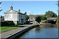
Canal at Swindon in Staffordshire
The Staffordshire and Worcestershire Canal passes through the village of Swindon her at Bridge No 40. Beyond the bridge is Swindon Lock.
Image: © Roger D Kidd
Taken: 25 Aug 2017
0.02 miles
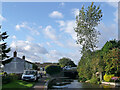
6
High Street
View from the Canal Bridge.
Image: © Gordon Griffiths
Taken: 13 Aug 2007
0.03 miles
7
Canal in Swindon, Staffordshire
This is the Staffordshire and Worcestershire Canal, looking north towards Swindon Bridge, No 40.
Image: © Roger Kidd
Taken: 29 Aug 2010
0.03 miles
8
Canal in Swindon, Staffordshire
This is the Staffordshire and Worcestershire Canal, looking north towards Swindon Bridge, No 40. The attendant British Waterways maintenance crew were about to leave following the felling and disposal of a very tall birch tree which was in danger of falling across the canal (if I remember correctly).
Image: © Roger Kidd
Taken: 29 Aug 2010
0.03 miles
9
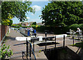
Swindon Lock near Wombourne, Staffordshire
A narrowboat on its way towards Wombourne is leaving the lock while Grandma looks on, no doubt anticipating her tasty lunch in The Green Man (recommended) a short while later.
The Staffordshire and Worcestershire Canal was opened in 1772, engineered by James Brindley. It joins the River Severn at Stourport to the Trent and Mersey Canal at Great Haywood Junction in Staffordshire. There are 43 locks (45 if you don't fancy the deep wide locks at Stourport) and the canal is 46 miles in length.
Image: © Roger D Kidd
Taken: 14 Jun 2011
0.03 miles
10
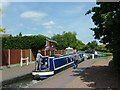
Leaving Swindon Lock near Wombourne, Staffordshire
A narrowboat on its way towards Wombourne is leaving the lock. The crew member from the waiting boat is winding down the ground paddle of the full lock to prevent more water passing through.
The Staffordshire and Worcestershire Canal was opened in 1772, engineered by James Brindley. It joins the River Severn at Stourport to the Trent and Mersey Canal at Great Haywood Junction in Staffordshire. There are 43 locks (45 if you don't fancy the deep wide locks at Stourport) and the canal is 46 miles in length.
Image: © Roger D Kidd
Taken: 14 Jun 2011
0.03 miles