1
Entrance to the Claughton Centre, Dudley
Viewed across Blowers Green Road. The Claughton Centre is a youth and community centre.
It was formerly the Upper Standard School, built in 1903.
Image: © Jaggery
Taken: 5 May 2012
0.02 miles
2
North side of the Claughton Centre, Dudley
Looking south along Blowers Green Road, past a house on the left, towards the Claughton Centre, now a youth and community centre. It was formerly the Upper Standard School, built in 1903.
Image: © Jaggery
Taken: 5 May 2012
0.02 miles
3
Blowers Green Primary School and Nursery Unit, Dudley
Viewed across Blowers Green Road.
Image: © Jaggery
Taken: 5 May 2012
0.04 miles
4
The Claughton Centre
Image: © Stephen Rogerson
Taken: 5 Sep 2013
0.04 miles
5
The Lamp Tavern
One of the eleven Bathams pubs.A small family brewery in Brierly Hill, established in 1877, and brewing a best bitter and mild ale.
Image: © Stephen Rogerson
Taken: 28 Oct 2011
0.08 miles
6
Lamp Cottage, Dudley
Part of the Lamp Tavern. The pub http://www.geograph.org.uk/photo/2989766 is behind Lamp Cottage, which has five en-suite B&B rooms.
Image: © Jaggery
Taken: 5 May 2012
0.08 miles
7
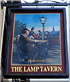
Pub sign, The Lamp Tavern, Dudley
The sign hangs from a frame on the wall of this http://www.geograph.org.uk/photo/2989766 pub.
Image: © Jaggery
Taken: 5 May 2012
0.08 miles
8
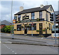
Bathams Lamp Tavern, Dudley
Pub at 116 High Street. Out of shot on the south side of the pub is a separate building, Lamp Cottage, http://www.geograph.org.uk/photo/2989793 where there are five B&B rooms.
Bathams is a Black Country brewery, established in 1877, based in Brierley Hill, West Midlands.
Image: © Jaggery
Taken: 5 May 2012
0.08 miles
9
Junction Street off Queens Cross, Dudley
Image: © Ian S
Taken: 3 Sep 2021
0.10 miles
10
Top of Junction Street, off Queen's Cross, Dudley
Junction Road drops down to meet Aston Road. Dudley is a hill town. The wooded hill on the skyline must be Netherton Park in
Image
Image: © Robin Stott
Taken: 29 Sep 2013
0.10 miles


