IMAGES TAKEN NEAR TO
Douglass Road, DUDLEY, DY2 8NE
Introduction
This page details the photographs taken nearby to Douglass Road, DY2 8NE by members of the Geograph project.
The Geograph project started in 2005 with the aim of publishing, organising and preserving representative images for every square kilometre of Great Britain, Ireland and the Isle of Man.

There are currently over 7.5m images from over14,400 individuals and you can help contribute to the project by visiting https://www.geograph.org.uk
Image Map
Images are licensed for reuse under creativecommons.org/licenses/by-sa/2.0
Notes
- Clicking on the map will re-center to the selected point.
- The higher the marker number, the further away the image location is from the centre of the postcode.
Image Listing (25 Images Found)
Images are licensed for reuse under creativecommons.org/licenses/by-sa/2.0
Image
Details
Distance
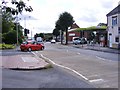
1
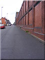
Blackacre Road
The view in Dudley.
Image: © Gordon Griffiths
Taken: 20 Aug 2012
0.07 miles
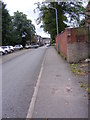
2
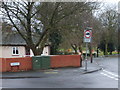
View from Paradise
View from Paradise and Prospect Row, Dixon's Green.
Image: © Gordon Griffiths
Taken: 6 Dec 2007
0.10 miles
3
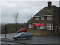
The Struggling Man
A Pub in Prospect Row.
Image: © Gordon Griffiths
Taken: 6 Dec 2007
0.13 miles
4
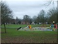
Buffery Park
The park from Prospect Row.
Image: © Gordon Griffiths
Taken: 6 Dec 2007
0.14 miles
5
Park and Shop
The view on Dixon's Green Road, Dudley.
Image: © Gordon Griffiths
Taken: 20 Aug 2012
0.17 miles
7
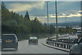
Dudley : Duncan Edwards Way A461
Looking along the Duncan Edwards Way.
Image: © Lewis Clarke
Taken: 27 Sep 2019
0.19 miles
8
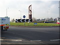
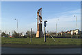
Dudley Town Centre Roundabout
The modern statuary at the centre of this roundabout declares that it marks "Dudley Town Centre".
Image: © Robert Neilson
Taken: 6 Feb 2007
0.20 miles
10
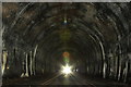
Dudley Railway Tunnel
constructed in the 1850's
Image: © David Fisher
Taken: 29 Jun 2011
0.20 miles