IMAGES TAKEN NEAR TO
Grainger Street, DUDLEY, DY2 8LG
Introduction
This page details the photographs taken nearby to Grainger Street, DY2 8LG by members of the Geograph project.
The Geograph project started in 2005 with the aim of publishing, organising and preserving representative images for every square kilometre of Great Britain, Ireland and the Isle of Man.

There are currently over 7.5m images from over14,400 individuals and you can help contribute to the project by visiting https://www.geograph.org.uk
Image Map
Images are licensed for reuse under creativecommons.org/licenses/by-sa/2.0
Notes
- Clicking on the map will re-center to the selected point.
- The higher the marker number, the further away the image location is from the centre of the postcode.
Image Listing (24 Images Found)
Images are licensed for reuse under creativecommons.org/licenses/by-sa/2.0
Image
Details
Distance
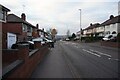
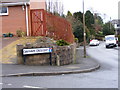
1
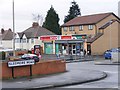
Buffery Road Post Office
The view from Sledmore Road, Dudley.
Image: © Gordon Griffiths
Taken: 11 Dec 2010
0.06 miles
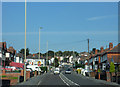

8
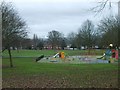
Buffery Park
The park from Prospect Row.
Image: © Gordon Griffiths
Taken: 6 Dec 2007
0.19 miles
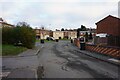
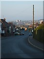
10
Oakham Crescent
The view from Oakham Avenue, Dudley.
Image: © Gordon Griffiths
Taken: 11 Dec 2010
0.20 miles