IMAGES TAKEN NEAR TO
Dingle Close, DUDLEY, DY2 8AG
Introduction
This page details the photographs taken nearby to Dingle Close, DY2 8AG by members of the Geograph project.
The Geograph project started in 2005 with the aim of publishing, organising and preserving representative images for every square kilometre of Great Britain, Ireland and the Isle of Man.

There are currently over 7.5m images from over14,400 individuals and you can help contribute to the project by visiting https://www.geograph.org.uk
Image Map
Images are licensed for reuse under creativecommons.org/licenses/by-sa/2.0
Notes
- Clicking on the map will re-center to the selected point.
- The higher the marker number, the further away the image location is from the centre of the postcode.
Image Listing (24 Images Found)
Images are licensed for reuse under creativecommons.org/licenses/by-sa/2.0
Image
Details
Distance
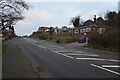
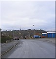
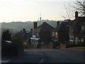
2
Oakham Crescent
The view from Oakham Avenue, Dudley.
Image: © Gordon Griffiths
Taken: 11 Dec 2010
0.09 miles
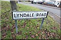
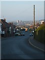
3
Uplands Road View
The view from Tansley Hill towards the Turner's Hill masts in Dudley.
Image: © Gordon Griffiths
Taken: 11 Dec 2010
0.11 miles
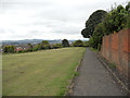
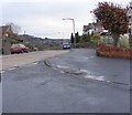
5
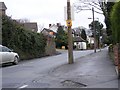
Oakham Road
The view up Tansley Hill in Dudley.
Image: © Gordon Griffiths
Taken: 11 Dec 2010
0.12 miles
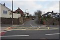
7
Elizabeth Groove
The view to Turner's Hill from Tansley Hill.
Image: © Gordon Griffiths
Taken: 8 Apr 2007
0.14 miles
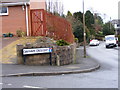
8
Warrens Hall Road View
The view of New Rowley Road and Rowley Hill, Dudley.
Image: © Gordon Griffiths
Taken: 11 Dec 2010
0.15 miles