IMAGES TAKEN NEAR TO
Birmingham New Road, DUDLEY, DY1 4DA
Introduction
This page details the photographs taken nearby to Birmingham New Road, DY1 4DA by members of the Geograph project.
The Geograph project started in 2005 with the aim of publishing, organising and preserving representative images for every square kilometre of Great Britain, Ireland and the Isle of Man.

There are currently over 7.5m images from over14,400 individuals and you can help contribute to the project by visiting https://www.geograph.org.uk
Image Map
Images are licensed for reuse under creativecommons.org/licenses/by-sa/2.0
Notes
- Clicking on the map will re-center to the selected point.
- The higher the marker number, the further away the image location is from the centre of the postcode.
Image Listing (529 Images Found)
Images are licensed for reuse under creativecommons.org/licenses/by-sa/2.0
Image
Details
Distance
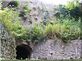
1
Tunnel Entrance, Dudley Limestone Mines.
Image: © David Lewis
Taken: 24 Apr 2009
0.00 miles
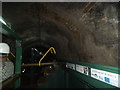
2
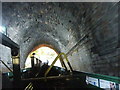
Lord Wards Tunnel
The view in the tunnel on the Dudley Canal.
Image: © Gordon Griffiths
Taken: 3 Sep 2015
0.01 miles
4

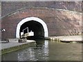
Dudley Tunnel
The canal on approaching the north entrance to the Tunnel.
Image: © Ashley Dace
Taken: 24 Mar 2011
0.02 miles
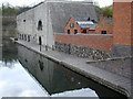
6
Shirts Mill Basin
The view of the Basin on the Dudley Canal.
Image: © Gordon Griffiths
Taken: 3 Sep 2015
0.03 miles
7

Dudley Canal Tunnel
Run by the Dudley canal trust, there are/were many caverns created when mining limestone. The trust run daily boat tours.
Image: © Ashley Dace
Taken: 24 Mar 2011
0.04 miles
10
Tunnel View
The view in the Dudley Canal Tunnel from the Dudley Canal Trust narrowboat George.
Image: © Gordon Griffiths
Taken: 3 Sep 2015
0.05 miles