IMAGES TAKEN NEAR TO
Sugars Lane, KIDDERMINSTER, DY14 9UN
Introduction
This page details the photographs taken nearby to Sugars Lane, DY14 9UN by members of the Geograph project.
The Geograph project started in 2005 with the aim of publishing, organising and preserving representative images for every square kilometre of Great Britain, Ireland and the Isle of Man.

There are currently over 7.5m images from over14,400 individuals and you can help contribute to the project by visiting https://www.geograph.org.uk
Image Map
Images are licensed for reuse under creativecommons.org/licenses/by-sa/2.0
Notes
- Clicking on the map will re-center to the selected point.
- The higher the marker number, the further away the image location is from the centre of the postcode.
Image Listing (6 Images Found)
Images are licensed for reuse under creativecommons.org/licenses/by-sa/2.0
Image
Details
Distance
1
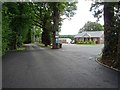
Holiday park
Holiday park near Far Forest to the west of Wyre Forest.
Image: © Philip Halling
Taken: 20 Jul 2019
0.07 miles
2
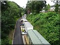
Former railway, now a caravan site
A rather unusual use for a former railway line. The line between the Severn Valley and Cleobury Mortimer closed in August 1962 and today it is part of a caravan park.
Image: © Philip Halling
Taken: 20 Jul 2019
0.18 miles
3
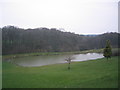
Stocked Trout Fishing Pond in Far Forest
A stocked trout fishing pond in Far Forest, beside a gully leading down into Wyre Forest.
Image: © O O'Brien
Taken: 24 Mar 2007
0.19 miles
4
Bridge crossing a former railway
Bridge crossing a former railway from the Severn Valley railway to Cleobury Mortimer.
Image: © Philip Halling
Taken: 20 Jul 2019
0.19 miles
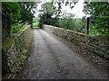
5
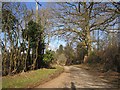
Lane, Far Forest
A route into the forest along a driveway to a few houses.
Image: © Richard Webb
Taken: 3 Apr 2013
0.23 miles
6
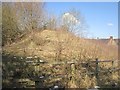
Site of a bridge buttress
A railway bridge had its deck removed sometime in the 1960s (passenger services stopped in 1961). More recently the buttresses were removed.
Image: © Richard Webb
Taken: 3 Apr 2013
0.24 miles