IMAGES TAKEN NEAR TO
Sugars Lane, KIDDERMINSTER, DY14 9TZ
Introduction
This page details the photographs taken nearby to Sugars Lane, DY14 9TZ by members of the Geograph project.
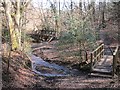
The Geograph project started in 2005 with the aim of publishing, organising and preserving representative images for every square kilometre of Great Britain, Ireland and the Isle of Man.

There are currently over 7.5m images from over14,400 individuals and you can help contribute to the project by visiting https://www.geograph.org.uk
Image Map
Images are licensed for reuse under creativecommons.org/licenses/by-sa/2.0
Notes
- Clicking on the map will re-center to the selected point.
- The higher the marker number, the further away the image location is from the centre of the postcode.
Image Listing (17 Images Found)
Images are licensed for reuse under creativecommons.org/licenses/by-sa/2.0
Image
Details
Distance
1
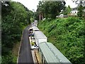
Former railway, now a caravan site
A rather unusual use for a former railway line. The line between the Severn Valley and Cleobury Mortimer closed in August 1962 and today it is part of a caravan park.
Image: © Philip Halling
Taken: 20 Jul 2019
0.07 miles
2
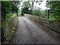
Bridge crossing a former railway
Bridge crossing a former railway from the Severn Valley railway to Cleobury Mortimer.
Image: © Philip Halling
Taken: 20 Jul 2019
0.08 miles
3
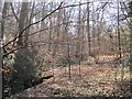
A Wyre dingle
Steep sided water course at Far Forest. Here only the steep sides are wooded, there are fields on the flatter ground.
Image: © Richard Webb
Taken: 3 Apr 2013
0.10 miles
4
A brace of bridges
A bridge over the Dowles Brook (back) and a tributary.
Image: © Richard Webb
Taken: 3 Apr 2013
0.11 miles
5
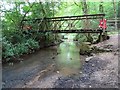
Footbridge crossing Dowles Brook
Footbridge crossing Dowles Brook which is currently closed and in a sorry state. The bridge has deteriorated since photographed in 2013 by Richard Webb Image]
Image: © Philip Halling
Taken: 20 Jul 2019
0.12 miles
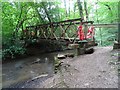
6
Footbridge crossing Dowles Brook
Footbridge crossing Dowles Brook which is currently closed and in a sorry state.
Image: © Philip Halling
Taken: 20 Jul 2019
0.12 miles
7
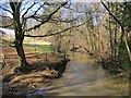
Dowles Brook
A famous Wyre Forest landmark, now full of melt water from heavy snowfalls.
Image: © Richard Webb
Taken: 3 Apr 2013
0.12 miles
8

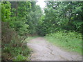
An old forest road
A track which went through the Wyre Forest from Far Forest to Kingswood. It descends to a useful footbridge over the Dowles Brook.
Image: © Richard Webb
Taken: 3 Apr 2013
0.13 miles
9
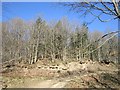
Brand Wood
The sunny, Shropshire side of Dowles Brook. On a cold day there was marked difference between this slope and the frosty shadows south of the brook.
Image: © Richard Webb
Taken: 3 Apr 2013
0.13 miles