IMAGES TAKEN NEAR TO
Clows Top, KIDDERMINSTER, DY14 9NN
Introduction
This page details the photographs taken nearby to DY14 9NN by members of the Geograph project.
The Geograph project started in 2005 with the aim of publishing, organising and preserving representative images for every square kilometre of Great Britain, Ireland and the Isle of Man.

There are currently over 7.5m images from over14,400 individuals and you can help contribute to the project by visiting https://www.geograph.org.uk
Image Map
Images are licensed for reuse under creativecommons.org/licenses/by-sa/2.0
Notes
- Clicking on the map will re-center to the selected point.
- The higher the marker number, the further away the image location is from the centre of the postcode.
Image Listing (10 Images Found)
Images are licensed for reuse under creativecommons.org/licenses/by-sa/2.0
Image
Details
Distance
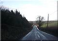
3
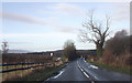
Road junction on B4202
Crossroads on the B4202 Clows Top to Cleobury Mortimer road.
Image: © Philip Halling
Taken: 9 Jun 2007
0.14 miles
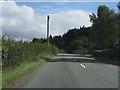
6
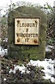
Old Milestone by the B4202, north of Bayton Common, Bayton Parish
Metal plate attached to stone post by the B4202, in parish of Bayton (Malvern Hills District), between entrance to Carlton Farm and waterworks, against hedge, on North-East side of road. Re-plated Worcester stone, erected by the Cleobury Mortimer to Bridgnorth Turnpike Trust in the 19th century.
Inscription reads: CLEOBURY / 3 / WORCESTER / 17
Carved benchmark.
Milestone Society National ID: WO_CLWO03.
Image: © J Higgins
Taken: 31 Jan 2015
0.16 miles
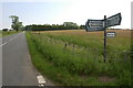
7
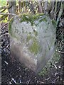
Old Boundary Marker on Bayton Pit Road
Parish Boundary Marker on the northeast side of Bayton Pit Road west of its junction with the B4202 Clows Top Road. Formerly on the boundary of Bayton and Mamble parishes, but now entirely in Bayton parish. Inscribed B, L. on its south face (Bayton parish) and M, L. on its east face (Mamble parish). The L is thought to represent Liberty, an area in which rights reserved to the king had been devolved into private hands.
Milestone Society National ID: WO_BAYTON04pb
Image: © J Atkinson
Taken: Unknown
0.18 miles
9
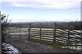
View over the Clees
From the Bayton Road near the highly landscaped Gay Meadows (named after the much missed Shrewsbury ground?).
Image: © Richard Webb
Taken: 27 Dec 2017
0.22 miles
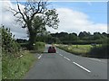
10
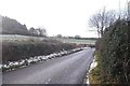
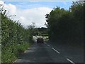
Road to Bayton
Melting snow in what was once a working coalfield.
Image: © Richard Webb
Taken: 27 Dec 2017
0.23 miles