IMAGES TAKEN NEAR TO
Clows Top Road, KIDDERMINSTER, DY14 9NB
Introduction
This page details the photographs taken nearby to Clows Top Road, DY14 9NB by members of the Geograph project.
The Geograph project started in 2005 with the aim of publishing, organising and preserving representative images for every square kilometre of Great Britain, Ireland and the Isle of Man.

There are currently over 7.5m images from over14,400 individuals and you can help contribute to the project by visiting https://www.geograph.org.uk
Image Map
Images are licensed for reuse under creativecommons.org/licenses/by-sa/2.0
Notes
- Clicking on the map will re-center to the selected point.
- The higher the marker number, the further away the image location is from the centre of the postcode.
Image Listing (5 Images Found)
Images are licensed for reuse under creativecommons.org/licenses/by-sa/2.0
Image
Details
Distance
1
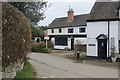
Bayton
A village at the end of several very narrow lanes.
Image: © Richard Webb
Taken: 5 Apr 2015
0.08 miles
2
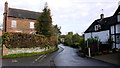
Cottages in Bayton
An isolated village in north-west Worcestershire.
Image: © Jonathan Billinger
Taken: 31 Oct 2013
0.09 miles
3
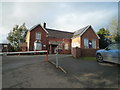
Bayton Church of England Primary School
This primary school at Bayton still thrives well, and is placed close to the church of St. Bartholomew's.
Image: © Fabian Musto
Taken: 12 Jan 2020
0.17 miles
4
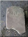
Old Boundary Marker near Bayton
Parish Boundary Marker which was on the north side of Clows Top Road east of Bayton village. Formerly on the boundary of Bayton and Mamble parishes, but now entirely in Bayton parish. Inscribed B, l. on its west face (Bayton parish) and M, L. on its south face (Mamble parish). The stone is broken and has been removed for repair.
Milestone Society National ID: WO_BAYTON03pb
Image: © J Atkinson
Taken: Unknown
0.17 miles
5
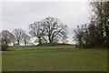
Fields, Bayton
The wooded spur looks artificial.
Image: © Richard Webb
Taken: 5 Apr 2015
0.25 miles