IMAGES TAKEN NEAR TO
Clows Top, KIDDERMINSTER, DY14 9HR
Introduction
This page details the photographs taken nearby to DY14 9HR by members of the Geograph project.
The Geograph project started in 2005 with the aim of publishing, organising and preserving representative images for every square kilometre of Great Britain, Ireland and the Isle of Man.

There are currently over 7.5m images from over14,400 individuals and you can help contribute to the project by visiting https://www.geograph.org.uk
Image Map
Images are licensed for reuse under creativecommons.org/licenses/by-sa/2.0
Notes
- Clicking on the map will re-center to the selected point.
- The higher the marker number, the further away the image location is from the centre of the postcode.
Image Listing (38 Images Found)
Images are licensed for reuse under creativecommons.org/licenses/by-sa/2.0
Image
Details
Distance
1
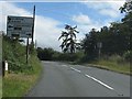
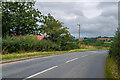
Sign and milepost on the B4202 approaching Clows Top
Note that the B4202 primary direction is Great Witley and compare with http://www.geograph.org.uk/photo/2571387. The road physically ends at Abberley, though Great Witley is the location more widely used on road signs.
Image: © Peter Whatley
Taken: 16 Aug 2011
0.03 miles
2
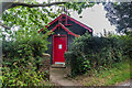
Clows Top Mission Room
"Tin tabernacle" dating from 1895, one of three places of worship in the parish of Mamble with Bayton.
Image: © Ian Capper
Taken: 31 Aug 2021
0.03 miles
3
Clows Top Mission Room
"Tin tabernacle" dating from 1895, one of three places of worship in the parish of Mamble with Bayton.
Image: © Ian Capper
Taken: 31 Aug 2021
0.04 miles
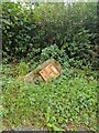
4
B4202
Image: © Ian Capper
Taken: 31 Aug 2021
0.04 miles
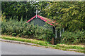
5
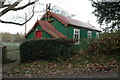
Clows Top Mission Room
Clows Top Mission Room was built in 1895 as a memorial to the Rev. John Cawood, and provided a place for Anglican worship in the village. The mission room was built with monies raised by donation from the 147 parishioners.
Image: © Philip Halling
Taken: 27 Nov 2010
0.04 miles
6
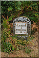
Old Milestone by the B4202, Cleobury Road, Clows Top
Metal plate attached to stone post by the B4202, in parish of BAYTON (MALVERN HILLS District), Cleobury Road, Clows Top, on the verge, on East side of road. Erected by the Cleobury Mortimer to Bridgnorth turnpike trust in the 19th century.
Inscription reads:- : CLEOBURY / 4 / WORCESTER / 16 :
Carved benchmark on lower front.
Listed Worcestershire and Worcester City HER Reference: WSM56951 https://www.heritagegateway.org.uk/Gateway/Results_Single.aspx?uid=MWR49449&resourceID=1035 also https://archaeologydataservice.ac.uk/archsearch/record?titleId=3393544
Milestone Society National ID: WO_CLWO04.
Image: © Lesley Jenkins
Taken: 23 Aug 2024
0.05 miles
7
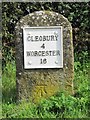
Old Milestone by the B4202, Cleobury Road, Clows Top
Metal plate attached to stone post by the B4202, in parish of BAYTON (MALVERN HILLS District), Cleobury Road, Clows Top, on the verge, on East side of road. Erected by the Cleobury Mortimer to Bridgnorth turnpike trust in the 19th century.
Inscription reads:- : CLEOBURY / 4 / WORCESTER / 16 :
Carved benchmark on lower front.
Listed Worcestershire and Worcester City HER Reference: WSM56951 https://www.heritagegateway.org.uk/Gateway/Results_Single.aspx?uid=MWR49449&resourceID=1035 also https://archaeologydataservice.ac.uk/archsearch/record?titleId=3393544
Milestone Society National ID: WO_CLWO04.
Image: © J Higgins
Taken: Unknown
0.05 miles
8
Milestone
Milestone on the B4202 near Clows Top, showing distances of 4 miles to Cleobury (Mortimer) and 16 miles to Wocester. For wider view see Image
Image: © Ian Capper
Taken: 31 Aug 2021
0.05 miles
9
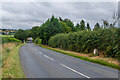
B4202
The B4202 near Clows Top. On the right is the milestone in Image
Image: © Ian Capper
Taken: 31 Aug 2021
0.06 miles