IMAGES TAKEN NEAR TO
Buckeridge Lane, KIDDERMINSTER, DY14 9DF
Introduction
This page details the photographs taken nearby to Buckeridge Lane, DY14 9DF by members of the Geograph project.
The Geograph project started in 2005 with the aim of publishing, organising and preserving representative images for every square kilometre of Great Britain, Ireland and the Isle of Man.

There are currently over 7.5m images from over14,400 individuals and you can help contribute to the project by visiting https://www.geograph.org.uk
Image Map
Images are licensed for reuse under creativecommons.org/licenses/by-sa/2.0
Notes
- Clicking on the map will re-center to the selected point.
- The higher the marker number, the further away the image location is from the centre of the postcode.
Image Listing (12 Images Found)
Images are licensed for reuse under creativecommons.org/licenses/by-sa/2.0
Image
Details
Distance
1
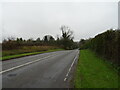
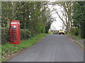
Cleobury Road, Fingerpost
The A4117 from Ludlow to Bewdley is the main link to the east from Ludlow. Signs point you around the green A49/A456 route, but most seem to go this way. A very scenic road, but you will get held up in Cleobury which is effectively single track and of course there is Clee Hill which was interesting today with the snow.
The eastern end of the road runs through the Wyre Forest.
Image: © Richard Webb
Taken: 27 Dec 2017
0.13 miles
2
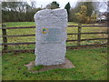
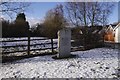
Rock parish Golden Jubilee Stone at Fingerpost
Erected by Rock Parish Council to celebrate the Queen's Golden Jubilee in 2012.
Placed well back from this oft-misjudged road junction - in the dark or wet weather it is notoriously tricky to spot and judge correctly.
Image: © Jeremy Bolwell
Taken: 27 Nov 2012
0.15 miles
3
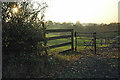
Green Dragon site
The cruck of a notorious junction. For years I thought the building which once stood here was a toll house, but was actually a pub, The Green Dragon. Being an industrial area: forestry and coal mining there were a lot of pubs here and a few still survive.
The stone is just a jubilee memorial.
Image: © Richard Webb
Taken: 27 Dec 2017
0.16 miles
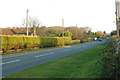
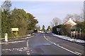
6
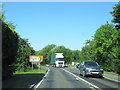
A456 at junction with A4117 for Far Forest & Cleobury
Image: © Roy Hughes
Taken: 25 Jun 2020
0.19 miles
7
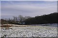
Field, Callow Hill
A cleared bit of the Wyre Forest in a densely populated area.
Image: © Richard Webb
Taken: 27 Dec 2017
0.20 miles
8
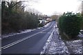
Fingerpost
The junction at the site of the Green Dragon, Callow Hill/Pound Bank. Here roads from Ludlow over Clee Hill (red) and Tenbury (green) meet. Today there was far more traffic on the A4117 to/from Cleobury (left) than on the signposted preferred route down the A456.
The junction is notorious for collisions, although visibility has been improved by removing the Green Dragon buildings in the angle. From here eastwards it is almost constant ribbon development along the A456 right into Birmingham.
Image: © Richard Webb
Taken: 27 Dec 2017
0.21 miles