IMAGES TAKEN NEAR TO
Cleobury Mortimer, KIDDERMINSTER, DY14 9BH
Introduction
This page details the photographs taken nearby to DY14 9BH by members of the Geograph project.
The Geograph project started in 2005 with the aim of publishing, organising and preserving representative images for every square kilometre of Great Britain, Ireland and the Isle of Man.

There are currently over 7.5m images from over14,400 individuals and you can help contribute to the project by visiting https://www.geograph.org.uk
Image Map
Images are licensed for reuse under creativecommons.org/licenses/by-sa/2.0
Notes
- Clicking on the map will re-center to the selected point.
- The higher the marker number, the further away the image location is from the centre of the postcode.
Image Listing (9 Images Found)
Images are licensed for reuse under creativecommons.org/licenses/by-sa/2.0
Image
Details
Distance
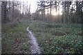
2
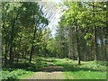
Path into the woodland
Popular spot for dog walking.
Image: © John M
Taken: 25 May 2013
0.13 miles
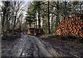
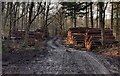
4
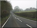
Cleobury Coppice
A Winter version of Image Since then the road has somewhat been taken over by brambles suggesting that most traffic now is recreational.
Image: © Richard Webb
Taken: 20 Feb 2020
0.23 miles
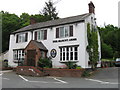
8
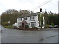
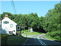
The Blount Arms public house near Cleobury Mortimer
Named for a family of local landowners, the Blount Baronets of nearby Mawley Hall (created baronets at the time of the English Civil War by King Charles I). Pronounced 'blunt' rather than blount I believe.
Image: © Jeremy Bolwell
Taken: 22 Nov 2012
0.24 miles