IMAGES TAKEN NEAR TO
Stottesdon, KIDDERMINSTER, DY14 8UW
Introduction
This page details the photographs taken nearby to DY14 8UW by members of the Geograph project.
The Geograph project started in 2005 with the aim of publishing, organising and preserving representative images for every square kilometre of Great Britain, Ireland and the Isle of Man.

There are currently over 7.5m images from over14,400 individuals and you can help contribute to the project by visiting https://www.geograph.org.uk
Image Map
Images are licensed for reuse under creativecommons.org/licenses/by-sa/2.0
Notes
- Clicking on the map will re-center to the selected point.
- The higher the marker number, the further away the image location is from the centre of the postcode.
Image Listing (8 Images Found)
Images are licensed for reuse under creativecommons.org/licenses/by-sa/2.0
Image
Details
Distance
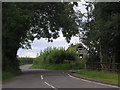
2
The Highlands - that way
Signpost on a junction near Stottesdon.
Image: © Richard Webb
Taken: 8 Apr 2014
0.02 miles

4
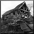
Fallen Barn
not only fallen spread everywhere
Image: © Neil Owen
Taken: 12 Apr 2007
0.08 miles
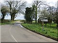
5
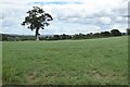
Tree in farmland
Tree in farmland near the village of Stottesdon.
Image: © Philip Halling
Taken: 5 Aug 2022
0.15 miles
6
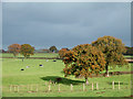
Grazing near Stottesdon, Shropshire
Looking towards Blundell Farm (just visible on the skyline).
Image: © Roger D Kidd
Taken: 6 Nov 2007
0.18 miles
7
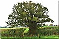
A Field Boundary Yew
This fine Veteran tree sits on a field boundary to the North East of the village of Stottesdon in Shropshire
Image: © paul wood
Taken: 24 Sep 2017
0.22 miles