IMAGES TAKEN NEAR TO
The Square, KIDDERMINSTER, DY14 8UB
Introduction
This page details the photographs taken nearby to The Square, DY14 8UB by members of the Geograph project.
The Geograph project started in 2005 with the aim of publishing, organising and preserving representative images for every square kilometre of Great Britain, Ireland and the Isle of Man.

There are currently over 7.5m images from over14,400 individuals and you can help contribute to the project by visiting https://www.geograph.org.uk
Image Map
Images are licensed for reuse under creativecommons.org/licenses/by-sa/2.0
Notes
- Clicking on the map will re-center to the selected point.
- The higher the marker number, the further away the image location is from the centre of the postcode.
Image Listing (81 Images Found)
Images are licensed for reuse under creativecommons.org/licenses/by-sa/2.0
Image
Details
Distance
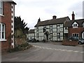
1
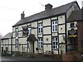
The Fighting Cocks, Stottesdon
This out-in-the-sticks pub truly is the centre of the community. Besides serving excellent locally-produced food at weekends, the pub also has its own shop (see separate entrance on right).
Image: © Ant Collis
Taken: 11 Nov 2007
0.02 miles
2
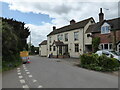
The Fighting Cocks pub in Stottesdon
A pub in a small, rural and reasonably isolated village needs to deliver in terms of food, drink and entertainment and this pub has been succeeding by the looks of it. I last visited in 2005 or so - so am probably overdue a return! It was shut when I tried to enter today.
Image: © Jeremy Bolwell
Taken: 12 May 2022
0.03 miles
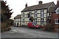
5
The only pub in the village
Some years ago two pubs graced Stottesdon, the other one being a brew-pub known as Dasher Downings (I forget the actual pub name). Although the building associated with that pub still exist they now comprise a private house. As for the Fighting Cocks, I've always found it a very convivial place.
Image: © Row17
Taken: 13 Mar 2003
0.04 miles
6
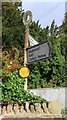
Old Direction Sign - Signpost by Station Road, Stottesdon Parish
Annulus finial - 2 Worboys arms; by the UC road, in parish of Stottesdon (Bridgnorth District), 'T' junction at pub, behind stone wall.
Surveyed
Milestone Society National ID: SA_SO6782.
Image: © Milestone Society
Taken: Unknown
0.04 miles
7
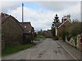
Stottesdon
A hilltop village. Not sure if there are one or two pubs here now.
Image: © Richard Webb
Taken: 8 Apr 2014
0.06 miles
8
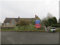
Stottesdon school
As so often in South Shropshire it is a church school.
There is a nursery as well, it even has a mission statement.
Image: © Richard Webb
Taken: 14 Feb 2015
0.06 miles
9
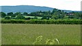
Stottesdon village and the Brown Clee
A view looking West towards Stottesdon village and the Brown Clee beyond
Image: © Peter Evans
Taken: 13 Jun 2014
0.07 miles
10
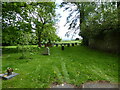
Part of the churchyard at St Marys, Stottesdon
The view from this bench stretches far, far, far to the south-east (I think) towards very distant horizons and adds to the sense of peace found here.
Image: © Jeremy Bolwell
Taken: 12 May 2022
0.10 miles