IMAGES TAKEN NEAR TO
Oreton, KIDDERMINSTER, DY14 8RP
Introduction
This page details the photographs taken nearby to DY14 8RP by members of the Geograph project.
The Geograph project started in 2005 with the aim of publishing, organising and preserving representative images for every square kilometre of Great Britain, Ireland and the Isle of Man.

There are currently over 7.5m images from over14,400 individuals and you can help contribute to the project by visiting https://www.geograph.org.uk
Image Map
Images are licensed for reuse under creativecommons.org/licenses/by-sa/2.0
Notes
- Clicking on the map will re-center to the selected point.
- The higher the marker number, the further away the image location is from the centre of the postcode.
Image Listing (7 Images Found)
Images are licensed for reuse under creativecommons.org/licenses/by-sa/2.0
Image
Details
Distance
1
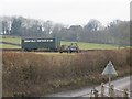
We are not in Brimfield anymore Toto
Trailer on the other side of Clee Hill, near Oreton, not Orleton.
Image: © Richard Webb
Taken: 14 Feb 2015
0.08 miles
2

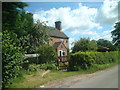
Footpath sign
The Simon Evans Way opposite Honeysuckle Cottage
Image: © planetearthisblue
Taken: 31 Jul 2007
0.12 miles
4
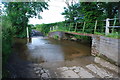
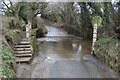
Ford at Prescott
This ford on the Farlow Brook is found close to Prescott.
Image: © John Walton
Taken: 8 Jun 2014
0.19 miles
5
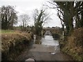
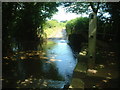
Ford through Farlow Brook
It has a good bottom and is easy to ride through. Great for washing off the mud, except that the lane to the north must be one of the muddiest I have ever ridden.
Image: © Richard Webb
Taken: 14 Feb 2015
0.20 miles