IMAGES TAKEN NEAR TO
Eagle Lane, KIDDERMINSTER, DY14 8RA
Introduction
This page details the photographs taken nearby to Eagle Lane, DY14 8RA by members of the Geograph project.
The Geograph project started in 2005 with the aim of publishing, organising and preserving representative images for every square kilometre of Great Britain, Ireland and the Isle of Man.

There are currently over 7.5m images from over14,400 individuals and you can help contribute to the project by visiting https://www.geograph.org.uk
Image Map
Images are licensed for reuse under creativecommons.org/licenses/by-sa/2.0
Notes
- Clicking on the map will re-center to the selected point.
- The higher the marker number, the further away the image location is from the centre of the postcode.
Image Listing (242 Images Found)
Images are licensed for reuse under creativecommons.org/licenses/by-sa/2.0
Image
Details
Distance
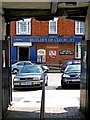
1
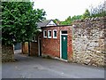
Public convenience, Eagle Lane
Tucked away in this back lane is this essential visitor amenity.
Image: © P L Chadwick
Taken: 5 Jul 2009
0.00 miles
2
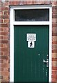
Notice on door of public convenience, Eagle Lane
The reason the door has been photographed is to show the notice stating that the building is maintained by South Shropshire District Council. However South Shropshire District Council is no more, as it has been incorporated into the new unitary authority called Shropshire Council. Presumably, at some stage, the notice will be replaced to reflect the change. Image
Image: © P L Chadwick
Taken: 5 Jul 2009
0.00 miles
3
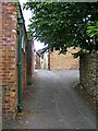
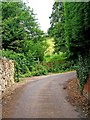
Eagle Lane, looking towards High Street
Photographed from near the bottom of the lane, looking towards the High Street. On the left is a public convenience. Image
Image: © P L Chadwick
Taken: 5 Jul 2009
0.01 miles
4
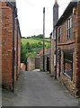
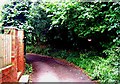
Eagle Lane
Eagle Lane is one of the town's many back lanes. In the distance is open countryside.
Image: © P L Chadwick
Taken: 5 Jul 2009
0.03 miles
5
Eagle Lane
At this point Eagle Lane takes a sharp bend to the right, and eventually leads out onto Tenbury Road. Immediately ahead is a stile giving access to a public footpath. Image; Image
Image: © P L Chadwick
Taken: 5 Jul 2009
0.03 miles
6
Speed restriction sign in Eagle Lane
Virtually hidden in the vegetation on the right is a 30mph speed restriction sign. This bend is so sharp and the lane itself so narrow, that going at 30mph around here would be near suicidal.
Image: © P L Chadwick
Taken: 5 Jul 2009
0.03 miles
7
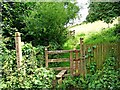
Stile to public footpath, off Eagle Lane
This stile at the bottom of Eagle Lane, gives access to a public footpath. The stile incorporates a wooden post (on the right), which can be lifted up to allow access for dogs. This is an increasingly common feature of stiles.
Image: © P L Chadwick
Taken: 5 Jul 2009
0.03 miles
8
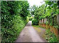
Eagle Lane near Tenbury Road
Eagle Lane becomes semi-rural in character in this area. In the distance is the junction with Tenbury Road.
Image: © P L Chadwick
Taken: 5 Jul 2009
0.04 miles
9
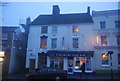
Cleobury fish bar, High St
Grade II listed building. http://www.britishlistedbuildings.co.uk/en-483889-23-cleobury-mortimer
Image: © N Chadwick
Taken: 29 Dec 2010
0.04 miles
10
Londis (Butler's of Cleobury) & Post Office, 22/23 High Street
Since previously photographed a year earlier (July 2008), the Londis Store & Post Office have been redecorated, with the emphasis on the trading name of Butler's of Cleobury. This view is from the passage running under the Talbot Hotel to Talbot Square. Image
Image: © L S Wilson
Taken: 5 Jul 2009
0.05 miles