IMAGES TAKEN NEAR TO
Stottesdon, KIDDERMINSTER, DY14 8NL
Introduction
This page details the photographs taken nearby to DY14 8NL by members of the Geograph project.
The Geograph project started in 2005 with the aim of publishing, organising and preserving representative images for every square kilometre of Great Britain, Ireland and the Isle of Man.

There are currently over 7.5m images from over14,400 individuals and you can help contribute to the project by visiting https://www.geograph.org.uk
Image Map
Images are licensed for reuse under creativecommons.org/licenses/by-sa/2.0
Notes
- Clicking on the map will re-center to the selected point.
- The higher the marker number, the further away the image location is from the centre of the postcode.
Image Listing (2 Images Found)
Images are licensed for reuse under creativecommons.org/licenses/by-sa/2.0
Image
Details
Distance
1
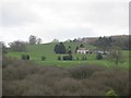
Mass House
An isolated dwelling between Bush Wood and Knowle Hill.
Image: © Richard Webb
Taken: 8 Apr 2014
0.02 miles
2
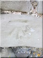
Ordnance Survey Cut Mark
This OS cut mark can be found on the NW face of a barn at Mass House Farm. It marks a point 159.953m above mean sea level.
Image: © Adrian Dust
Taken: 21 Nov 2015
0.02 miles