
IMAGES TAKEN NEAR TO
High Street, KIDDERMINSTER, DY14 8DH
Introduction
This page details the photographs taken nearby to High Street, DY14 8DH by members of the Geograph project.
The Geograph project started in 2005 with the aim of publishing, organising and preserving representative images for every square kilometre of Great Britain, Ireland and the Isle of Man.

There are currently over 7.5m images from over14,400 individuals and you can help contribute to the project by visiting https://www.geograph.org.uk
Image Map
Images are licensed for reuse under creativecommons.org/licenses/by-sa/2.0
Notes
- Clicking on the map will re-center to the selected point.
- The higher the marker number, the further away the image location is from the centre of the postcode.
Image Listing (274 Images Found)
Images are licensed for reuse under creativecommons.org/licenses/by-sa/2.0
Image
Details
Distance
1
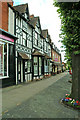
Old houses in High Street
Looking in the direction of The Talbot Hotel. The shop front on the left edge of this view is that of MacCartneys, Estate Agents, 38 High Street.
Image: © P L Chadwick
Taken: 20 Jul 2008
0.00 miles
2
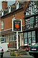
The Talbot Hotel sign, 29 High Street
The sign shows the arms of Sir John Talbot, Earl of Shrewsbury. The hotel is named after him, not after the white Talbot hound.
Image: © P L Chadwick
Taken: 20 Jul 2008
0.00 miles
3
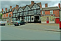
The Talbot Hotel, 29 High Street
Probably the oldest and largest surviving licensed hotel or public house in Cleobury Mortimer. However when photographed in July 2008 the hotel was closed for refurbishment, with no indication of when it will reopen. It seems to be now owned by the Suffolk brewers Greene King.Fortunately keen drinkers have plenty of alternatives including The Stable Tavern which can be reached by walking through the covered carriageway at the right end of the hotel. Unusually the hotel is not named after the long extinct white coloured Talbot hound, but is named after Sir John Talbot, Earl of Shrewsbury. Parts of the hotel date back to the 16th century. Next door on the right is the local greengrocers, Fred's Fruit & Veg.
Image: © P L Chadwick
Taken: 20 Jul 2008
0.00 miles
4
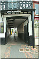
Covered carriageway at Talbot Hotel leading to Talbot Square
Despite the sign over the carriageway, cars would have to find another route to the car park, as the central rail prevents access through here by cars. In the past horses and coaches would have come through here to reach the stables and yard at the rear of The Talbot Hotel. Today this passage is used by pedestrians and cyclists to reach The Stable Tavern, a food store, the local Police Station and Talbot Square.
Image: © P L Chadwick
Taken: 20 Jul 2008
0.00 miles
5
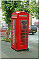
Red public telephone kiosk, High Street
This traditional red public telephone kiosk survives because this part of Cleobury Mortimer is in a preservation area. It is near to The Talbot Hotel.
Image: © P L Chadwick
Taken: 20 Jul 2008
0.00 miles
6
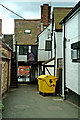
Covered carriageway to High Street
This view taken from the back of The Talbot Hotel shows the carriageway under the first floor of the hotel. It leads from Talbot Square into the High Street.
Image: © P L Chadwick
Taken: 20 Jul 2008
0.00 miles
7
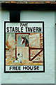
The Stable Tavern pub sign, 1 Talbot Square
Tucked away behind The Talbot Hotel can be found The Stable Tavern.
Image: © P L Chadwick
Taken: 20 Jul 2008
0.01 miles
8

The sign for The Talbot public house
The current sign can be seen in Image It appears to be a completely different design. The pie shop in the background can be seen here Image
Image: © Geoffery E Williams
Taken: 21 Oct 1959
0.01 miles
9
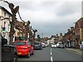
Trees in High Street, Cleobury Mortimer
A mixture of buildings line the main street, with these trees on the north
Image: © David Smith
Taken: 20 May 2013
0.01 miles
10
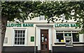
Lloyd's Bank (Cleobury Mortimer)
Housed in a Georgian building on No. 39 High Street, this is the only bank left in Cleobury Mortimer. The cashing machine to the right was destroyed in December 2015, which led to a rebuild on that section of the building. This was taken from the A4117 road.
Image: © Fabian Musto
Taken: 17 Sep 2021
0.01 miles