IMAGES TAKEN NEAR TO
Hartmann Close, KIDDERMINSTER, DY14 8DE
Introduction
This page details the photographs taken nearby to Hartmann Close, DY14 8DE by members of the Geograph project.
The Geograph project started in 2005 with the aim of publishing, organising and preserving representative images for every square kilometre of Great Britain, Ireland and the Isle of Man.

There are currently over 7.5m images from over14,400 individuals and you can help contribute to the project by visiting https://www.geograph.org.uk
Image Map
Images are licensed for reuse under creativecommons.org/licenses/by-sa/2.0
Notes
- Clicking on the map will re-center to the selected point.
- The higher the marker number, the further away the image location is from the centre of the postcode.
Image Listing (122 Images Found)
Images are licensed for reuse under creativecommons.org/licenses/by-sa/2.0
Image
Details
Distance
1
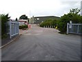
Muller England
Shropshire can be defined as "Between Mullers". At the southern end of the county is this long established engineering company. They make hydraulic components on the western edge of Cleobury Mortimer. (The northern Müller is at Market Drayton, and have cornered the market in yogurt.)
Image: © Richard Webb
Taken: 21 Jun 2006
0.08 miles
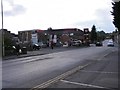
4
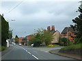
Ludlow Road/High Street, Cleobury Mortimer
On the right, a residential cul-de-sac, Vaughan Road
Image: © David Smith
Taken: 20 May 2013
0.10 miles
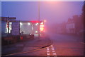
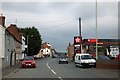
5
Cleobury Garage
The view in High Street in Cleobury Mortimer.
Image: © Gordon Griffiths
Taken: 7 Oct 2013
0.10 miles
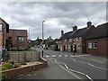
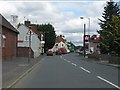
6
High Street, Cleobury Mortimer
On the right, the Texaco filling station
Image: © David Smith
Taken: 20 May 2013
0.10 miles
8
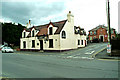
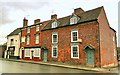
The Three Horse Shoes, 53 High Street
This Banks public house is currently, July 2008, closed with the windows boarded up. Quite a number of this brewery's pubs round the Shrops/Worcs border seem to be in the same position with their ultimate fate not yet disclosed.
Image
Update October 2012:- The building re-opened as a restaurant in February 2011. See:- Image
Image: © P L Chadwick
Taken: 20 Jul 2008
0.11 miles
9
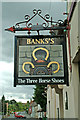
The Three Horse Shoes, 53 High Street, pub sign
Pub sign which is still displayed outside The Three Horse Shoes, which is currently closed (July 2008). The pub is on the main road to Cleehill and Ludlow, the A4117, which can be seen in the background.
Update - October 2012:- The sign has now gone as the pub was converted into a restaurant called Addison's, which opened in February 2011.
Image
Image
Image: © P L Chadwick
Taken: 20 Jul 2008
0.11 miles
10
Cottages in High Street
A typical group of cottages in the High Street of this charming Shropshire town. The fresh coats of Farrow and Ball on two houses on the right should help their sale. The butchers shop appears to close on Saturdays.
Image: © Philip Pankhurst
Taken: 7 Dec 2013
0.12 miles