IMAGES TAKEN NEAR TO
High Street, KIDDERMINSTER, DY14 8BY
Introduction
This page details the photographs taken nearby to High Street, DY14 8BY by members of the Geograph project.
The Geograph project started in 2005 with the aim of publishing, organising and preserving representative images for every square kilometre of Great Britain, Ireland and the Isle of Man.

There are currently over 7.5m images from over14,400 individuals and you can help contribute to the project by visiting https://www.geograph.org.uk
Image Map
Images are licensed for reuse under creativecommons.org/licenses/by-sa/2.0
Notes
- Clicking on the map will re-center to the selected point.
- The higher the marker number, the further away the image location is from the centre of the postcode.
Image Listing (263 Images Found)
Images are licensed for reuse under creativecommons.org/licenses/by-sa/2.0
Image
Details
Distance
1
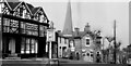
Cleobury Mortimer leaving the High Street to join Church Street
Eagle lane is to the right of the photographer.
Image: © Antony Ewart Smith
Taken: Unknown
0.01 miles
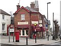
2
Cleobury Post Office
The view in Church Street in Cleobury Mortimer.
Image: © Gordon Griffiths
Taken: 7 Oct 2013
0.01 miles
3
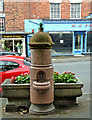
Horse Trough & Drinking Fountain, High Street
These were erected in memory of Captain W H Trow who died in the Boer War in 1900. He was in the Shropshire Light Infantry. According to the Public Monument and Sculpture Association's records, "The drinking fountain and horse trough that make up this commemorative monument are two separate pieces. The trough, now planted with flowers, stands next to the road. The drinking fountain consists of a circular granite fountain head, with the inscription and an inscribed pattern, and a small round bowl for the drinking fountain. The fountain head is surmounted with a sandstone dome". The Society say the fountain is not working as the tap is missing.
Image: © P L Chadwick
Taken: 20 Jul 2008
0.01 miles
4
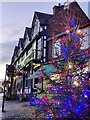
Christmas tree along Cleobury Mortimer High Street
Next to the Talbot Hotel.
Image: © Mat Fascione
Taken: 29 Dec 2020
0.01 miles
5
Old Toll House, Cleobury Mortimer
Toll House in the parish of Cleobury Mortimer, The Crusty Cob Tea Rooms, 18, Church Street (A4117), DY14 8BX.
Grade II listed.
List Entry Number: 1383454 https://historicengland.org.uk/listing/the-list/list-entry/1383454
Surveyed
Milestone Society National ID: SA.CLM04
Image: © Milestone Society
Taken: Unknown
0.01 miles
6
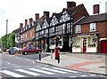
The Talbot Hotel, 29 High Street
The hotel is now open again and owned by the brewers Greene King. A year ago (July 2008) it was closed. Image
Image: © P L Chadwick
Taken: 5 Jul 2009
0.01 miles
7
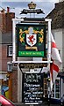
The new sign of The Talbot Hotel, 29 High Street
Another year, another sign. This picture shows the new sign for the long-established Talbot Hotel, and it includes the Greene King name and logo above. In 2008 the hotel had a completely different sign:- Image There is also a fascinating photo on this site of the sign used in 1959 (yet another version):- Image There may well be other variants over the years that have not been recorded. Signs do change, so it's important to photograph them as well as the hotels, inns and pubs themselves! Image
Image: © P L Chadwick
Taken: 5 Jul 2009
0.01 miles
8
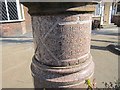
Memorial fountain, Cleobury
Erected in the memory of a Boer War army officer: Captain WH Trow, KSLI.
Image: © Richard Webb
Taken: 3 Apr 2013
0.01 miles
9
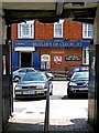
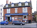
Londis (Butler's of Cleobury) & Post Office, 22/23 High Street
Since previously photographed a year earlier (July 2008), the Londis Store & Post Office have been redecorated, with the emphasis on the trading name of Butler's of Cleobury. This view is from the passage running under the Talbot Hotel to Talbot Square. Image
Image: © L S Wilson
Taken: 5 Jul 2009
0.02 miles
10
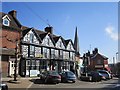
Talbot Hotel, Cleobury Mortimer
A centre piece in this thriving high street. The famous crooked spire shows well from this side.
Image: © Richard Webb
Taken: 3 Apr 2013
0.02 miles