IMAGES TAKEN NEAR TO
Furlongs Road, KIDDERMINSTER, DY14 8AR
Introduction
This page details the photographs taken nearby to Furlongs Road, DY14 8AR by members of the Geograph project.
The Geograph project started in 2005 with the aim of publishing, organising and preserving representative images for every square kilometre of Great Britain, Ireland and the Isle of Man.

There are currently over 7.5m images from over14,400 individuals and you can help contribute to the project by visiting https://www.geograph.org.uk
Image Map
Images are licensed for reuse under creativecommons.org/licenses/by-sa/2.0
Notes
- Clicking on the map will re-center to the selected point.
- The higher the marker number, the further away the image location is from the centre of the postcode.
Image Listing (202 Images Found)
Images are licensed for reuse under creativecommons.org/licenses/by-sa/2.0
Image
Details
Distance
2
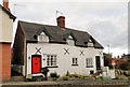
23 & 24 Lower Street, Cleobury Mortimer
A pair of charming listed cottages at the Eastern end of town. The right hand cottage could be yours for £ 132,500.
Image: © Philip Pankhurst
Taken: 7 Dec 2013
0.07 miles
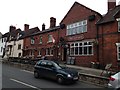
6
The Old Lion in Cleobury Mortimer
A Grade II Listed public house along the A4117 Lower Street in Cleobury Mortimer. It was formerly a blacksmiths.
Image: © Mat Fascione
Taken: 28 Jan 2024
0.08 miles
7
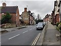
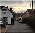
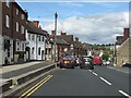
A4117 Lower Street in Cleobury Mortimer
Image: © Mat Fascione
Taken: 28 Jan 2024
0.08 miles
8
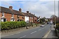
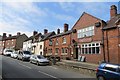
Lower Street, Cleobury
The A4117 leaving town.
Image: © Richard Webb
Taken: 5 Apr 2015
0.08 miles
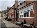
10
The Old Lion
Pub, Lower Street, Cleobury.
Image: © Richard Webb
Taken: 5 Apr 2015
0.08 miles