IMAGES TAKEN NEAR TO
Oreton, KIDDERMINSTER, DY14 0TR
Introduction
This page details the photographs taken nearby to DY14 0TR by members of the Geograph project.
The Geograph project started in 2005 with the aim of publishing, organising and preserving representative images for every square kilometre of Great Britain, Ireland and the Isle of Man.

There are currently over 7.5m images from over14,400 individuals and you can help contribute to the project by visiting https://www.geograph.org.uk
Image Map
Images are licensed for reuse under creativecommons.org/licenses/by-sa/2.0
Notes
- Clicking on the map will re-center to the selected point.
- The higher the marker number, the further away the image location is from the centre of the postcode.
Image Listing (3 Images Found)
Images are licensed for reuse under creativecommons.org/licenses/by-sa/2.0
Image
Details
Distance
1
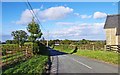
Unclassified road to Oreton, Shropshire
The village hall is on this road.
Image: © P L Chadwick
Taken: 14 Oct 2012
0.22 miles
2
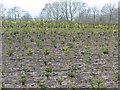
Nursery
Young trees opposite Melville Chapel
Image: © Richard Webb
Taken: 2 Apr 2007
0.23 miles
3

Farlow & Oreton Village Hall, near Farlow
The hall serves the villages of Farlow and Oreton and is a little way from both. It seems to date from the early 1950's.
Image: © P L Chadwick
Taken: 14 Oct 2012
0.25 miles