IMAGES TAKEN NEAR TO
Lanes End, KIDDERMINSTER, DY14 0RH
Introduction
This page details the photographs taken nearby to Lanes End, DY14 0RH by members of the Geograph project.
The Geograph project started in 2005 with the aim of publishing, organising and preserving representative images for every square kilometre of Great Britain, Ireland and the Isle of Man.

There are currently over 7.5m images from over14,400 individuals and you can help contribute to the project by visiting https://www.geograph.org.uk
Image Map
Images are licensed for reuse under creativecommons.org/licenses/by-sa/2.0
Notes
- Clicking on the map will re-center to the selected point.
- The higher the marker number, the further away the image location is from the centre of the postcode.
Image Listing (2 Images Found)
Images are licensed for reuse under creativecommons.org/licenses/by-sa/2.0
Image
Details
Distance
1
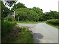
Country road junction at Lane's End, near Farlow
The road to the small village of Silvington at its junction at Lane's End near with the road to Farlow.
Image: © Philip Halling
Taken: 14 Jun 2017
0.08 miles
2
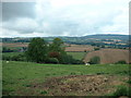
Farmland near Lane's End
Looking northwest, towards Brown Clee Hill, with Lowe Farm visible left of centre.
Image: © David Medcalf
Taken: 14 Sep 2006
0.17 miles