IMAGES TAKEN NEAR TO
Cleeton St. Mary, KIDDERMINSTER, DY14 0QP
Introduction
This page details the photographs taken nearby to DY14 0QP by members of the Geograph project.
The Geograph project started in 2005 with the aim of publishing, organising and preserving representative images for every square kilometre of Great Britain, Ireland and the Isle of Man.

There are currently over 7.5m images from over14,400 individuals and you can help contribute to the project by visiting https://www.geograph.org.uk
Image Map
Images are licensed for reuse under creativecommons.org/licenses/by-sa/2.0
Notes
- Clicking on the map will re-center to the selected point.
- The higher the marker number, the further away the image location is from the centre of the postcode.
Image Listing (11 Images Found)
Images are licensed for reuse under creativecommons.org/licenses/by-sa/2.0
Image
Details
Distance
1
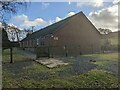
Cleeton St. Mary village hall
Here is the village hall at Cleeton Lane in Cleeton St. Mary, built during the late twentieth century.
Image: © Fabian Musto
Taken: 13 Jan 2023
0.04 miles
2
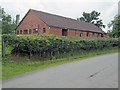
Cleeton St Mary and Silvington Village Hall
Situated near the Cleeton St Mary lane near The Birches.
Image: © Trevor Rickard
Taken: 22 Aug 2010
0.04 miles
3

Trees by Cleeton Lane
These trees are north from the village hall at Cleeton St. Mary.
Image: © Fabian Musto
Taken: 13 Jan 2023
0.05 miles
4
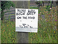
Warning sign near The Birches
This excellent home-made warning sign almost perfectly reflects the situation on the ground. So good it could have been a portrait - Image
Image: © Trevor Rickard
Taken: 22 Aug 2010
0.06 miles
5
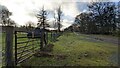
Car park at Cleeton St. Mary
The private track in the distance leads to the Blue Stone Farm, north from Magpie Hill. This car park is by the village hall at Cleeton St. Mary.
Image: © Fabian Musto
Taken: 13 Jan 2023
0.06 miles
6
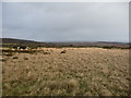
Sheep grazing high up above Catherton Common
Sheep enjoy the grazing in fields beside the road, with views down onto Catherton Common behind and squally weather passing further away behind that.
Image: © Jeremy Bolwell
Taken: 5 Jan 2012
0.08 miles
7
Cleeton St. Mary
The village sign for Cleeton St. Mary is by Cleeton Lane, situated northwest from the village hall.
Image: © Fabian Musto
Taken: 13 Jan 2023
0.13 miles
8
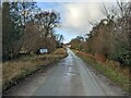
Road high up near Clee Hill
The network of lane and roads around here are often quiet with motorised traffic and as a driver you are likely to have to be aware of all road users from sheep and lambs to walking groups.
Image: © Jeremy Bolwell
Taken: 5 Jan 2012
0.16 miles
9
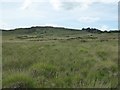
View to Magpie Hill
View to Magpie Hill, part of the much larger Titterstone Clee Hill, much of which is rough grazing common land.
Image: © Philip Halling
Taken: 14 Jun 2017
0.23 miles
10
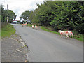
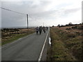
Rush hour at Cleeton St Mary
About as busy as it gets around here as the sheep wander up the lane to the entrance to The Birches. What a good thing the warning sign was in place - Image
Image: © Trevor Rickard
Taken: 22 Aug 2010
0.23 miles