IMAGES TAKEN NEAR TO
Cleeton St. Mary, KIDDERMINSTER, DY14 0QD
Introduction
This page details the photographs taken nearby to DY14 0QD by members of the Geograph project.
The Geograph project started in 2005 with the aim of publishing, organising and preserving representative images for every square kilometre of Great Britain, Ireland and the Isle of Man.

There are currently over 7.5m images from over14,400 individuals and you can help contribute to the project by visiting https://www.geograph.org.uk
Image Map
Images are licensed for reuse under creativecommons.org/licenses/by-sa/2.0
Notes
- Clicking on the map will re-center to the selected point.
- The higher the marker number, the further away the image location is from the centre of the postcode.
Image Listing (26 Images Found)
Images are licensed for reuse under creativecommons.org/licenses/by-sa/2.0
Image
Details
Distance
1
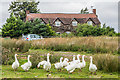
Random Farm
A flock of geese in front of Random Farm.
Image: © Ian Capper
Taken: 6 Aug 2020
0.00 miles
2
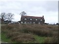
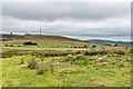
Lower Random Farmhouse
Situated high up on Titterstone Clee this must be a very exposed spot for weather.
Image: © John M
Taken: 3 Nov 2007
0.03 miles
3
Hoar Edge
Random Cottage Farm and Random Farm atop Hoar Edge.
Image: © Ian Capper
Taken: 6 Aug 2020
0.04 miles
4
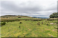
Titterstone Clee Hill and Brown Clee
Looking across to two significant Shropshire hills from near Random Farm, with a third, The Wrekin, just visible behind Brown Clee.
Image: © Ian Capper
Taken: 6 Aug 2020
0.06 miles
5
Titterstone Clee Hill, Brown Clee and The Wrekin
Looking across to three significant Shropshire hills from near Random Farm.
Image: © Ian Capper
Taken: 6 Aug 2020
0.07 miles
7
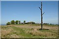
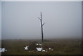
Three-Forked Pole and Random Farm
When I came across this I thought it was a dead tree, reminiscent of a First World War battlefield. It is in fact a marker called the Three-Forked Pole which stands on the meeting point of three parishes. Random Farm can be seen in the background and stands about 460m above sea level on Titterstone Clee Hill, a hill which is generally referred to, and wrongly, as Clee Hill. That said, this part of Titterstone Clee Hill is simply called Clee Hill. For a view from this elevated spot to the south-east see: Image]
Image: © Philip Halling
Taken: 14 May 2018
0.11 miles
9
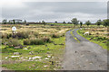
Track
Sheep alongside a track leading to Random, with one of the buildings of Random Farm in the left background.
Image: © Ian Capper
Taken: 6 Aug 2020
0.12 miles