IMAGES TAKEN NEAR TO
Catherton Road, KIDDERMINSTER, DY14 0LQ
Introduction
This page details the photographs taken nearby to Catherton Road, DY14 0LQ by members of the Geograph project.
The Geograph project started in 2005 with the aim of publishing, organising and preserving representative images for every square kilometre of Great Britain, Ireland and the Isle of Man.

There are currently over 7.5m images from over14,400 individuals and you can help contribute to the project by visiting https://www.geograph.org.uk
Image Map
Images are licensed for reuse under creativecommons.org/licenses/by-sa/2.0
Notes
- Clicking on the map will re-center to the selected point.
- The higher the marker number, the further away the image location is from the centre of the postcode.
Image Listing (5 Images Found)
Images are licensed for reuse under creativecommons.org/licenses/by-sa/2.0
Image
Details
Distance
1
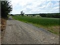
Farmland track
Farmland track giving access to a cottage near Little Stepple Farm.
Image: © Philip Halling
Taken: 14 Jun 2017
0.04 miles
2
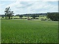
Cottage in farmland
Cottage in farmland viewed across an arable field near Little Stepple Farm.
Image: © Philip Halling
Taken: 14 Jun 2017
0.10 miles
3
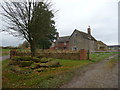
Little Stepple Farm house
An old farm house that is in fact still lived in.
Image: © Jeremy Bolwell
Taken: 19 Nov 2012
0.11 miles
4
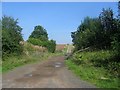
Farm road, Stepple
The entrance to Stepple Hall, the road running through arable farmland.
Image: © Richard Webb
Taken: 12 Sep 2005
0.15 miles
5
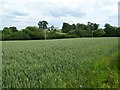
Wheat field near Stepple Hall
View across a field of growing wheat with Stepple Hall farm in the background.
Image: © Philip Halling
Taken: 14 Jun 2017
0.22 miles