IMAGES TAKEN NEAR TO
Hopton Bank, KIDDERMINSTER, DY14 0HQ
Introduction
This page details the photographs taken nearby to Hopton Bank, DY14 0HQ by members of the Geograph project.
The Geograph project started in 2005 with the aim of publishing, organising and preserving representative images for every square kilometre of Great Britain, Ireland and the Isle of Man.

There are currently over 7.5m images from over14,400 individuals and you can help contribute to the project by visiting https://www.geograph.org.uk
Image Map
Images are licensed for reuse under creativecommons.org/licenses/by-sa/2.0
Notes
- Clicking on the map will re-center to the selected point.
- The higher the marker number, the further away the image location is from the centre of the postcode.
Image Listing (31 Images Found)
Images are licensed for reuse under creativecommons.org/licenses/by-sa/2.0
Image
Details
Distance
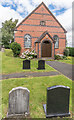
1
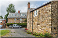
The Old School House
House at the top of Hopton Bank, previously marked on maps as Chapel House. Although the immediate foreground section would appear to be an extension, the part beyond, with a chimney above the gable end, was the original Hopton Bank Methodist Chapel, built in 1837, before replacement by the current building (see Image) in 1880.
Image: © Ian Capper
Taken: 6 Aug 2020
0.00 miles
2
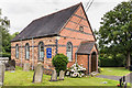
Bethel chapel, Foxwood
Dated 1890 I think. Still apparently in use.
Image: © Jeremy Bolwell
Taken: 3 Jan 2013
0.01 miles
3
Bethel chapel at Foxwood on Hopton Bank
A handsome old chapel, still apparently in use.
Image: © Jeremy Bolwell
Taken: 3 Jan 2013
0.01 miles
4
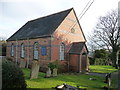
Bethel Primitive Methodist Chapel, Hopton Bank
Methodist chapel built in 1880 on a plot adjacent to an earlier chapel from 1837, built to serve the local coal mining community.
Image: © Ian Capper
Taken: 6 Aug 2020
0.01 miles
5
Bethel Primitive Methodist Chapel, Hopton Bank
Methodist chapel built in 1880 on a plot adjacent to an earlier chapel from 1837, built to serve the local coal mining community.
Image: © Ian Capper
Taken: 6 Aug 2020
0.01 miles
6
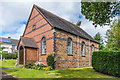
Bethel Primitive Methodist Chapel, Hopton Bank
Methodist chapel built in 1880 on a plot adjacent to an earlier chapel from 1837, built to serve the local coal mining community.
Image: © Ian Capper
Taken: 6 Aug 2020
0.01 miles
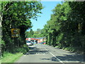
8
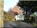
Hopton Bank
Garage, houses and a Methodist church at the top of Hopton Bank, the name given to the route of the A4117 as it climbs up from Hopton Wafers and a name now applied to the village itself.
Image: © Ian Capper
Taken: 6 Aug 2020
0.02 miles
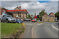
9
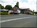
Murco petrol station at Doddington
A tradition petrol filling station with numerous car parked around the site, this on is at Doddington beside the A4117.
Image: © Philip Halling
Taken: 14 Jun 2017
0.02 miles
10
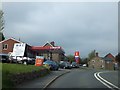
Filling station and garage near Foxwood
Two signs inform the motorist that this Murco station performs MOT tests.
Image: © David Smith
Taken: 20 May 2013
0.02 miles