IMAGES TAKEN NEAR TO
Holly Waste, KIDDERMINSTER, DY14 0HB
Introduction
This page details the photographs taken nearby to Holly Waste, DY14 0HB by members of the Geograph project.
The Geograph project started in 2005 with the aim of publishing, organising and preserving representative images for every square kilometre of Great Britain, Ireland and the Isle of Man.

There are currently over 7.5m images from over14,400 individuals and you can help contribute to the project by visiting https://www.geograph.org.uk
Image Map
Images are licensed for reuse under creativecommons.org/licenses/by-sa/2.0
Notes
- Clicking on the map will re-center to the selected point.
- The higher the marker number, the further away the image location is from the centre of the postcode.
Image Listing (6 Images Found)
Images are licensed for reuse under creativecommons.org/licenses/by-sa/2.0
Image
Details
Distance
1
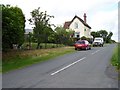
Waterboard House.
On the very edge of the square, a house built to service the Elan Aqueduct. This pipeline runs to Birmingham, from Cwm Elan in Radnorshire and supplies the West Midlands with much of its drinkingwater. There are no pumping stations and the water runs by gravity. However there are lots of ups and downs, it crosses Clee Hill and many rivers, and Birmingham is on a plateau - the outlet is still below the inlet and the water can travel the 110km without pumping.
http://history.powys.org.uk/history/rhayader/aqueduct1.html
Image: © Richard Webb
Taken: 21 Jun 2006
0.01 miles
2
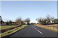
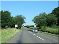
A4117 approaching Hollywaste crossroads
Image: © Peter Whatley
Taken: 16 Aug 2011
0.01 miles
3
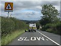
Crossroads at Hollywaste
From eastbound A4117
Image: © John Firth
Taken: 16 Mar 2012
0.04 miles
4
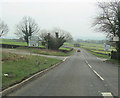
Neen Savage and Milson Crossroads on A4117
Image: © Roy Hughes
Taken: 25 Jun 2020
0.04 miles
5
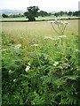
Hedgerow, Hollywaste
Midsummer hedgerow with oak fringed arable fields beyond.
Image: © Richard Webb
Taken: 21 Jun 2006
0.06 miles