IMAGES TAKEN NEAR TO
Milson, KIDDERMINSTER, DY14 0BW
Introduction
This page details the photographs taken nearby to DY14 0BW by members of the Geograph project.
The Geograph project started in 2005 with the aim of publishing, organising and preserving representative images for every square kilometre of Great Britain, Ireland and the Isle of Man.

There are currently over 7.5m images from over14,400 individuals and you can help contribute to the project by visiting https://www.geograph.org.uk
Image Map
Images are licensed for reuse under creativecommons.org/licenses/by-sa/2.0
Notes
- Clicking on the map will re-center to the selected point.
- The higher the marker number, the further away the image location is from the centre of the postcode.
Image Listing (7 Images Found)
Images are licensed for reuse under creativecommons.org/licenses/by-sa/2.0
Image
Details
Distance
1
Haybridge Cottage
Close to Mill Brook, near Milson in Shropshire.
Image: © Mat Fascione
Taken: 16 May 2012
0.07 miles
2
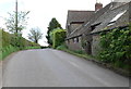
Haybridge Cottage
Close to Mill Brook, near Milson in Shropshire.
Image: © Mat Fascione
Taken: 16 May 2012
0.07 miles
3
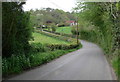
Lane to Milson
The house is Oak Lodge.
Image: © Mat Fascione
Taken: 16 May 2012
0.14 miles

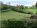
6
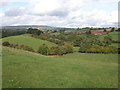
Mill brook valley
View to the north-west with Clee Hill in the background.
Image: © Philip Halling
Taken: 8 Oct 2006
0.23 miles
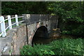
7
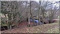
Millbrook, Haybridge
The Mill Brook runs off Clee Hill to the Teme via the Rea Brook.
Image: © Richard Webb
Taken: 27 Dec 2011
0.25 miles