IMAGES TAKEN NEAR TO
Cleobury Mortimer, KIDDERMINSTER, DY14 0AE
Introduction
This page details the photographs taken nearby to DY14 0AE by members of the Geograph project.
The Geograph project started in 2005 with the aim of publishing, organising and preserving representative images for every square kilometre of Great Britain, Ireland and the Isle of Man.

There are currently over 7.5m images from over14,400 individuals and you can help contribute to the project by visiting https://www.geograph.org.uk
Image Map
Images are licensed for reuse under creativecommons.org/licenses/by-sa/2.0
Notes
- Clicking on the map will re-center to the selected point.
- The higher the marker number, the further away the image location is from the centre of the postcode.
Image Listing (4 Images Found)
Images are licensed for reuse under creativecommons.org/licenses/by-sa/2.0
Image
Details
Distance
2
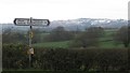
Signpost , Tenbury to Cleobury road
A bit of rubbish, all too common now in rural England hangs from a signpost before a snow covered Clee Hill. A bitter day, no doubt playing havoc with lambing.
Image: © Richard Webb
Taken: 4 Apr 2012
0.11 miles
3
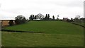
Bank beneath Bransley Villa
Grassland on the southern slopes of Clee Hill.
Image: © Richard Webb
Taken: 4 Apr 2012
0.18 miles