IMAGES TAKEN NEAR TO
Mart Lane, STOURPORT-ON-SEVERN, DY13 9FF
Introduction
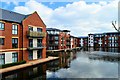
This page details the photographs taken nearby to Mart Lane, DY13 9FF by members of the Geograph project.
The Geograph project started in 2005 with the aim of publishing, organising and preserving representative images for every square kilometre of Great Britain, Ireland and the Isle of Man.

There are currently over 7.5m images from over14,400 individuals and you can help contribute to the project by visiting https://www.geograph.org.uk
Image Map
Images are licensed for reuse under creativecommons.org/licenses/by-sa/2.0
Notes
- Clicking on the map will re-center to the selected point.
- The higher the marker number, the further away the image location is from the centre of the postcode.
Image Listing (1077 Images Found)
Images are licensed for reuse under creativecommons.org/licenses/by-sa/2.0
Image
Details
Distance
1
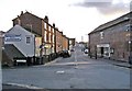
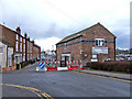
Mart Lane
The buildings on the left were built by the Staffordshire and Worcestershire Canal Company as warehousing, housing and offices. The lane ends by the River Severn at the Angel Inn. On its way it passes a canal basin on the left which had been filled in, but has recently been remade. Image
Image: © P L Chadwick
Taken: 20 Nov 2008
0.01 miles
2
Mart Lane, Stourport
Late 18th century housing, built by the canal company and used as both employee housing and offices.
Image: © Philip Pankhurst
Taken: 11 Apr 2019
0.01 miles
3
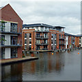
Waters Edge, Stourport Basins, Worcestershire
Waters Edge is a Barratt Homes project, apartments completed in 2013 around the (reinstated) Lichfield Basin. The lack of lights at night revealed very few occupants at the time of this image.
Image: © Roger D Kidd
Taken: 23 Jun 2013
0.01 miles
4

Lichfield Basin, Stourport
Lichfield Basin lives again after being dug out when the modern housing development was built. However, due to a legal issue a stop plank prevents any boats from entering. Seen on a freezing morning, with an all-over covering of ice.
Image: © Philip Pankhurst
Taken: 20 Jan 2022
0.01 miles
5
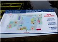
"Water's Edge" new housing development site information board
This information board has been placed at the side of the bridge which goes over the channel connecting the re-opened canal basin to the existing basins. Image
Image: © P L Chadwick
Taken: 29 Dec 2009
0.01 miles
6
Lichfield Basin, Stourport
Originally built in 1810 and surrounded by warehouses, the basin was filled in and all buildings demolished. The basin has now been excavated and refilled and is now surrounded by apartments. Sadly, no boats are currently allowed in.
Image: © Philip Pankhurst
Taken: 22 Mar 2019
0.02 miles
7
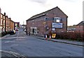
Old canal company building
This building has been renovated as part of the regeneration of this part of town.
Image: © P L Chadwick
Taken: 8 Apr 2008
0.02 miles
8
Old warehouse Mart Lane
This old warehouse has the words "London and North West Railway Shropshire Union Railway and Canal" emblazoned along two of its external walls. Following renovation, it has recently been occupied by a chandlers, which seems a very good use for this historic building. Some months previously it looked like this
Image
Image: © P L Chadwick
Taken: 20 Nov 2008
0.02 miles
9
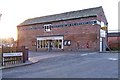
Limekiln Chandlers Mart Lane
In 2008 Limekiln Chandlers of Compton Wolverhampton opened their second chandlery in this former canal warehouse. It's good to see also that the Victorian postbox built into the external wall has now re-opened for use.
http://www.limekilnchandlers.co.uk/
Image
Image: © P L Chadwick
Taken: 20 Nov 2008
0.02 miles
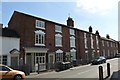
10
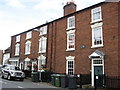
Terrace of houses on Mart Lane, Stourport Upon Severn
The sign on the houses reads ’This building is an ancient monument of special historic interest’
Image: © Richard Rogerson
Taken: 17 Jul 2010
0.02 miles