IMAGES TAKEN NEAR TO
Baldwin Road, STOURPORT-ON-SEVERN, DY13 9AX
Introduction
This page details the photographs taken nearby to Baldwin Road, DY13 9AX by members of the Geograph project.
The Geograph project started in 2005 with the aim of publishing, organising and preserving representative images for every square kilometre of Great Britain, Ireland and the Isle of Man.

There are currently over 7.5m images from over14,400 individuals and you can help contribute to the project by visiting https://www.geograph.org.uk
Image Map
Images are licensed for reuse under creativecommons.org/licenses/by-sa/2.0
Notes
- Clicking on the map will re-center to the selected point.
- The higher the marker number, the further away the image location is from the centre of the postcode.
Image Listing (209 Images Found)
Images are licensed for reuse under creativecommons.org/licenses/by-sa/2.0
Image
Details
Distance
1
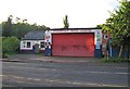
Stourport Auto Centre, Baldwin Road, Stourport-on-Severn
A garage and M.O.T testing centre.
Image: © P L Chadwick
Taken: 15 Jul 2012
0.04 miles
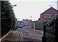
2
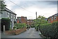
Holly Road
A narrow residential road. In the other direction it leads to the Bird in Hand public house, some old cottages, and there is access to the Staffs & Worcs Canal towpath.
Image: © P L Chadwick
Taken: 19 Sep 2010
0.07 miles
3
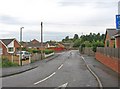
Mill Road (2)
A quiet residential road, tucked away in a backwater of the town.
Image
Image: © P L Chadwick
Taken: 19 Sep 2010
0.07 miles
4
Orchard Close
A residential cul-de-sac road, off Mill Road.
Image: © P L Chadwick
Taken: 19 Sep 2010
0.08 miles
5
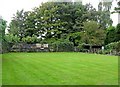
Bird in Hand (4) - the bowling green, 5 Holly Road
Not many pubs still have their own bowling green. The best known in this area is probably the Hadley Bowling Green Inn at Hadley Heath, near Droitwich. However the Bird in Hand also has a green, which is just across Holly Road, opposite the front of the pub. They also have their own Bird in Hand Bowling Club.
For more pictures of the pub, please see:- Image
Image: © P L Chadwick
Taken: 19 Sep 2010
0.08 miles
6
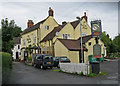
Bird in Hand (1), 5 Holly Road
An old and popular canalside pub. The other side fronts onto the Staffs & Worcs Canal towpath, from which there is access. It has a beer garden, and most unusually, a bowling green. The pub is easy to spot, when walking or boating along the canal. But from the town side, it is tucked away at the end of a narrow residential street, in a quiet part of town, with no indication that it is here.
Image
Image
Image
Image: © P L Chadwick
Taken: 19 Sep 2010
0.09 miles
7
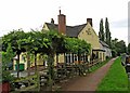
Bird in Hand (2), 5 Holly Road
This view shows the canal as seen from the towpath of the Staffordshire & Worcestershire Canal. With the closure of The Tontine, as a pub, some years ago, this is now one of the three remaining canalside pubs in Stourport. Although the furthest from the town centre, it probably has the best location. The beer garden can be seen in this view. It is believed the pub was in use as far back as 1771, when the canal was built, although some features are earlier than that. It would have been very popular with people working and living on the canal narrowboats.
The white buildings further along the towpath, are old cottages, which originally were the homes of canal workers.
For more pictures of the pub, please see:- Image
Image: © P L Chadwick
Taken: 19 Sep 2010
0.09 miles
8
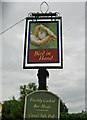
Bird in Hand (3) - pub sign, 5 Holly Road
The sign of the pub, which is attached to a post, outside the pub, at the top of Holly Road.
For more pictures of the pub, please see:- Image
Image: © P L Chadwick
Taken: 19 Sep 2010
0.09 miles
9
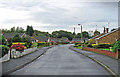
Mill Close
Mill Close is a residential road and cul-de-sac, containing bungalows. It is a turning off Mill Road.
Image: © P L Chadwick
Taken: 19 Sep 2010
0.09 miles
10
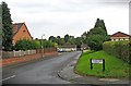
Summerfield Road
One of the town's residential roads, near the Staffs & Worcs Canal.
Image: © P L Chadwick
Taken: 28 Dec 2009
0.09 miles