
IMAGES TAKEN NEAR TO
Field End, STOURPORT-ON-SEVERN, DY13 8UD
Introduction
This page details the photographs taken nearby to Field End, DY13 8UD by members of the Geograph project.
The Geograph project started in 2005 with the aim of publishing, organising and preserving representative images for every square kilometre of Great Britain, Ireland and the Isle of Man.

There are currently over 7.5m images from over14,400 individuals and you can help contribute to the project by visiting https://www.geograph.org.uk
Image Map
Images are licensed for reuse under creativecommons.org/licenses/by-sa/2.0
Notes
- Clicking on the map will re-center to the selected point.
- The higher the marker number, the further away the image location is from the centre of the postcode.
Image Listing (25 Images Found)
Images are licensed for reuse under creativecommons.org/licenses/by-sa/2.0
Image
Details
Distance
1
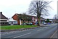
Local shops in Lower Lickhill Road
This part of Stourport, which includes the Lickhill Estate, is quite a way from the town centre and bus services in this area of the town are infrequent. These shops, which include a SPAR store, are therefore very useful for local residents. On the far left can be seen part of the local pub, The Stagborough Arms Image
Image: © P L Chadwick
Taken: 11 Jan 2009
0.13 miles
2
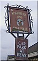
The Stagborough Arms pub sign, 81 Lower Lickhill Road
Named after Stagborough Hill from which this part of the town can be seen Image
The pub has had a new sign:- Image
Image: © P L Chadwick
Taken: 11 Jan 2009
0.14 miles
3
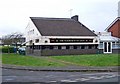
The Stagborough Arms, 81 Lower Lickhill Road
The Stagborough Arms dates from the second half of the 20th century, and was built as an estate pub for the adjacent Lickhill Estate. It is the only pub at this end of Stourport. To survive in these difficult times for pubs, it's advisable to offer something extra as well as good beer. The Stagborough Arms does this by presenting lots of live music, and indeed claims to be "Stourport's premier live music venue". It has also been singled out by the local branch of the Campaign for Real Ale, as it offers several varieties of real beer to its customers. The pub also has its own website http://www.stagborougharms.co.uk/
Compared to many pubs, The Stagborough Arms is a relatively new one, but even so it is on at least its third name. The current name relates to Stagborough Hill from which this part of the town can be seen Image
Image: © P L Chadwick
Taken: 11 Jan 2009
0.14 miles
4
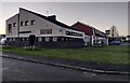
The Stagborough Arms in Stourport-on-Severn
A public house along Lower Lickhill Road.
Image: © Mat Fascione
Taken: 26 Dec 2022
0.16 miles
5
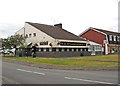
The Stagborough Arms, 81 Lower Lickhill Road, Stourport-on-Severn
This is a new photo of the Stagborough Arms, taken in August 2011. The pub has had permission to install its own micro brewery, which seems to be a first for Stourport. The brewery's products will be sold as Osspice Ales. The pub has also changed its sign.
For more details about the pub see:- Image
The new sign:- Image
Image: © P L Chadwick
Taken: 29 Aug 2011
0.16 miles
6
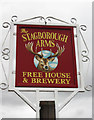
The new sign of The Stagborough Arms, 81 Lower Lickhill Road, Stourport-on-Severn
Image: © P L Chadwick
Taken: 29 Aug 2011
0.16 miles

8
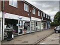
Row of shops, Lower Lickhill Road
Stourport.
Image: © Richard Webb
Taken: 7 Jul 2024
0.17 miles
9

Crops near the Lickhill Manor Caravan Park
Image: © Mat Fascione
Taken: 28 Jul 2013
0.17 miles
10

Private road to Lickhill Manor Caravan Park, Stourport-on-Severn, Worcs
The road also serves Lickhill Manor House, which for many years was used as a nursing home. Earlier this week this area was badly flooded and impassable. The flood waters from the River Severn reached the height of the gate in the right hand corner of this photograph. A public footpath passes through the gate and across the field down to the river, where it joins the Severn Way.
Image: © P L Chadwick
Taken: 30 Jan 2021
0.17 miles