IMAGES TAKEN NEAR TO
Katrine Road, STOURPORT-ON-SEVERN, DY13 8QB
Introduction
This page details the photographs taken nearby to Katrine Road, DY13 8QB by members of the Geograph project.
The Geograph project started in 2005 with the aim of publishing, organising and preserving representative images for every square kilometre of Great Britain, Ireland and the Isle of Man.

There are currently over 7.5m images from over14,400 individuals and you can help contribute to the project by visiting https://www.geograph.org.uk
Image Map
Images are licensed for reuse under creativecommons.org/licenses/by-sa/2.0
Notes
- Clicking on the map will re-center to the selected point.
- The higher the marker number, the further away the image location is from the centre of the postcode.
Image Listing (5 Images Found)
Images are licensed for reuse under creativecommons.org/licenses/by-sa/2.0
Image
Details
Distance
1
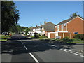
Stourport - Burlish Crossing at Windermere Way
Image: © Peter Whatley
Taken: 21 Jun 2010
0.11 miles
2
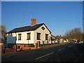
Burlish Crossing
The rise in the road and this converted Gate Keepers house are all that remains of the former original Severn Valley Railway level crossing on the route from Hartlebury to Bewdley.
Image: © David Stowell
Taken: 11 Dec 2005
0.17 miles
4
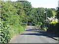
Kingsway
Further along this road the residential area of Stourport-on-Severn begins.
Image: © P L Chadwick
Taken: 7 May 2010
0.21 miles
5
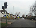
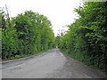
Crossroads at Lickhill
Bewdley Road North heading into Stourport
Image: © John Firth
Taken: 16 Mar 2012
0.23 miles