IMAGES TAKEN NEAR TO
Longbank, STOURPORT-ON-SEVERN, DY13 0UD
Introduction
This page details the photographs taken nearby to Longbank, DY13 0UD by members of the Geograph project.
The Geograph project started in 2005 with the aim of publishing, organising and preserving representative images for every square kilometre of Great Britain, Ireland and the Isle of Man.

There are currently over 7.5m images from over14,400 individuals and you can help contribute to the project by visiting https://www.geograph.org.uk
Image Map
Images are licensed for reuse under creativecommons.org/licenses/by-sa/2.0
Notes
- Clicking on the map will re-center to the selected point.
- The higher the marker number, the further away the image location is from the centre of the postcode.
Image Listing (13 Images Found)
Images are licensed for reuse under creativecommons.org/licenses/by-sa/2.0
Image
Details
Distance
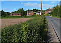
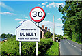
2
Approaching Dunley
The A451 about to pass through Dunley. Blink and you'll miss it!
Image: © Peter Whatley
Taken: 3 Jan 2009
0.08 miles
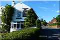
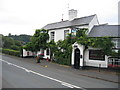
4
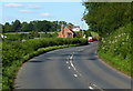
A451 at Lower Strand Cottages
On the southern edge of Dunley village.
Image: © Mat Fascione
Taken: 12 Jun 2014
0.13 miles
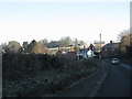
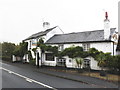
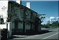
7
The Dog Inn, Dunley
Public house along the A451.
Image: © Mat Fascione
Taken: 12 Jun 2014
0.18 miles
9
The Dog Inn, Dunley
A more recent image can be seen here Image
Image: © Geoffery E Williams
Taken: 18 Jun 1957
0.20 miles
10
The Dog Inn, Dunley
This is the pub shown on the OS Map beside the Stourport - Witley road in the SE corner of the square.
Image: © David Stowell
Taken: 13 Aug 2006
0.21 miles