IMAGES TAKEN NEAR TO
Hilderic Crescent, DUDLEY, DY1 2ET
Introduction
This page details the photographs taken nearby to Hilderic Crescent, DY1 2ET by members of the Geograph project.
The Geograph project started in 2005 with the aim of publishing, organising and preserving representative images for every square kilometre of Great Britain, Ireland and the Isle of Man.

There are currently over 7.5m images from over14,400 individuals and you can help contribute to the project by visiting https://www.geograph.org.uk
Image Map
Images are licensed for reuse under creativecommons.org/licenses/by-sa/2.0
Notes
- Clicking on the map will re-center to the selected point.
- The higher the marker number, the further away the image location is from the centre of the postcode.
Image Listing (36 Images Found)
Images are licensed for reuse under creativecommons.org/licenses/by-sa/2.0
Image
Details
Distance
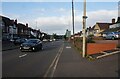
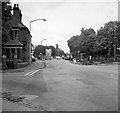
2
Brierley Hill : Stourbridge Road A461
Looking along Stourbridge Road.
Image: © Lewis Clarke
Taken: 27 Sep 2019
0.08 miles
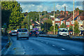
3
Brierley Hill : Stourbridge Road A461
Looking along the A461.
Image: © Lewis Clarke
Taken: 27 Sep 2019
0.09 miles
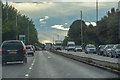
5
Holly Hall
Holly Hall probably in the 1970's. Viewed from the Stourbridge Road junction with Pensnett Road towards Scotts Green.
Image: © Brian Clift
Taken: 1 Jun 1975
0.09 miles
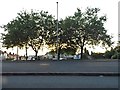
6
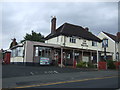
The King William, Holly Hall, Dudley
On Pensnett Road.
Image: © JThomas
Taken: 22 Aug 2019
0.10 miles
7
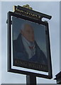
Sign for the King William, Holly Hall, Dudley
See Image] for context.
Image: © JThomas
Taken: 22 Aug 2019
0.10 miles
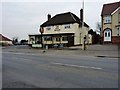

10
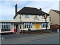
The King William
A Pub on the Pensnett Road.
Image: © Gordon Griffiths
Taken: 9 Apr 2007
0.11 miles