IMAGES TAKEN NEAR TO
Maughan Street, DUDLEY, DY1 2BA
Introduction
This page details the photographs taken nearby to Maughan Street, DY1 2BA by members of the Geograph project.
The Geograph project started in 2005 with the aim of publishing, organising and preserving representative images for every square kilometre of Great Britain, Ireland and the Isle of Man.

There are currently over 7.5m images from over14,400 individuals and you can help contribute to the project by visiting https://www.geograph.org.uk
Image Map
Images are licensed for reuse under creativecommons.org/licenses/by-sa/2.0
Notes
- Clicking on the map will re-center to the selected point.
- The higher the marker number, the further away the image location is from the centre of the postcode.
Image Listing (102 Images Found)
Images are licensed for reuse under creativecommons.org/licenses/by-sa/2.0
Image
Details
Distance
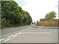
1
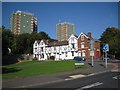
Mixed housing, western edge of Dudley town centre
Distinctive two- and three-storey houses in Maughan Street are dwarfed by blocks of flats up the hill: Clent Court, left, and Claveley Court, right. The view is from Russells Hall Road.
Image: © Robin Stott
Taken: 29 Sep 2013
0.01 miles
2
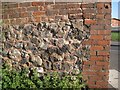
Brick-capped rubble wall, Maughan Street, Dudley
The rubble seems to be a mixture of natural rock and lumps of slag; in some pieces of the latter gas bubbles can be seen Image The brick capping may have been simply to raise the height of the wall, but it may be to protect the original lime mortar (presumed) from the weather. Guessing, the wall has been repointed with modern cement mortar.
Image: © Robin Stott
Taken: 29 Sep 2013
0.02 miles
3
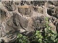
Detail of brick-capped rubble wall, Maughan Street, Dudley
A close-up of components of the rubble wall in Image It is assumed to be slag or some other industrial waste material. The large piece left of centre shows signs of having flowed and solidified. Right of centre is material that has been gasified: bubbles of different sizes can be seen. Could it be slag from glassmaking? There was a glassworks in Parkway Road. Guessing, the wall has been repointed with modern cement mortar. A similar wall is seen in Image
Image: © Robin Stott
Taken: 29 Sep 2013
0.02 miles
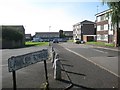
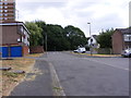
4
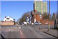
Maughan Street Island
The view in Dudley.
Image: © Gordon Griffiths
Taken: 25 Feb 2018
0.03 miles
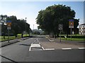
5
Grange Road View
The view down the road in Dudley.
Image: © Gordon Griffiths
Taken: 18 Jun 2016
0.04 miles
7
Bus stops and signs, upper end of Russells Hall Road, Dudley
Seen from the junction with Maughan Street.
Image: © Robin Stott
Taken: 29 Sep 2013
0.05 miles
8
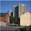
East on Himley Street towards Clent Court flats, Dudley
On the left is the Park Congregational Chapel Image
Image: © Robin Stott
Taken: 29 Sep 2013
0.05 miles
9
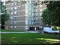
Moving day at Clent Court flats, off Vicarage Prospect, Dudley
Image: © Robin Stott
Taken: 29 Sep 2013
0.05 miles
10
Lawley Street View
The view in Dudley.
Image: © Gordon Griffiths
Taken: 9 Jul 2018
0.06 miles